ViewLand Use Table of Contents
INTRODUCTION
There are many land uses in Boone County that have made it the attractive place to live, work, do business, and recreate. Proximity to the City of Cincinnati has made Boone County and its rural amenities a long desired suburb. Transportation has played a key role in this. Multiple modes of transportation, including the Ohio River, an international airport, rail lines, and the highway system has aided in the rapid business and population growth that has occurred in Boone County. In addition, as a result of the Cincinnati-Northern Kentucky International Airport (CVG) being located within Boone County, many jobs have naturally migrated to the area as well as including the rapidly emerging logistics industry. Also, Boone County has been experiencing steady commercial success over the past several decades with major retail centers along the interstate corridors. In addition, the incredible beauty of the western half of Boone County has long been a valuable resource not only to those who live there, but also for people wanting to experience a more rural and historic setting. Rabbit Hash and other river towns along with the Big Bone Lick State Historic Site are just a few of the natural attractions that exist in Boone County. These land uses have developed over long periods of time and will continue to do so. The key to this and any long range land use plan is how to balance these uses so that they do not negatively impact each other to the point of eliminating natural resources or economic opportunities.
This Comprehensive Plan is intended to be a tool for the management of growth and development in Boone County. The growth of the county can have positive benefits for the present and future population if it takes place within the context of a comprehensive plan which recognizes and integrates the various elements that comprise Boone County. This growth management is directed by the Goals and Objectives of this plan which recommend the efficient use of land resources, physical improvements, public facilities, and protection and enhancement of the natural and social environment. Goals and Objectives require that growth and development be coordinated and well-planned.
The Land Use Element of this plan recognizes that growth will occur in portions of Boone County. This plan utilizes a 20 to 25-year planning horizon for future land use recommendations, and further, the document is mandated to be reviewed and/or updated every five years. This element contains future land use development guidelines, land use classifications for the existing and future land uses, text regarding the future land use for the entire county as divided into 24 land use characteristic areas, a map identifying 2017 existing land uses, and a map depicting year 2040 specific future land use patterns throughout Boone County. This plan is a tool designed to enable officials in Boone County and the Planning Commission to manage the location and timing of the various types of development, to assure adequate and fiscally responsible provision of infrastructure and public services in order to assure that adjoining land uses are compatible, and to assure that negative impacts to the environment are minimized. The various types of development will demand different levels of infrastructure as a major component of the Land Use Element. The OKI Land Use Commission has identified many of the regional impacts and cost issues associated with suburban development. The Commission’s 2010 report presents regional issues, trends, conditions, goals, objectives, and policies for Transportation, Public Facilities and Services, Natural Systems, Housing, Economic Development, and Land Use sectors. The report contains a policy plan that encourages local governments and planning agencies to pursue more concentrated land use patterns, more efficient transportation decisions, prompt and coordinated public services provisions, mixed-use development design, diverse housing choices, environmental protection, fiscally responsible decisions, and cooperation with other jurisdictions.
Urban service areas are those parts of the county where public services, infrastructure, and community facilities are available or planned to support an urban development pattern. This is not to say that all of the land within the urban service areas should be developed; there remains a need to protect or maintain some land as open space within these higher density areas. Urban service areas should contain water supply systems, sewage treatment, utilities, police and fire protection, schools, recreation facilities, and easy access to major transportation routes. Future urban service areas, or the expansion of existing urban service areas, should develop where land resources are available and demand is sufficient to assure efficient utilization of proposed public services and infrastructure. Development of future urban service areas should be permitted when adequate services are provided as part of the development or when full public services are made available. Until such services are provided, future urban service areas should only contain low density development, which is compatible with the ultimate planned land uses, but not dependent on full urban services. Areas not anticipated to experience substantial urban growth are planned for less intense, rural development which will create little or no demand for urban services. Any extension of services to these areas could commit them to development and should be undertaken carefully.
The Land Use Element is intended to provide general guidelines for all future development and to permit the management of growth in Boone County. This plan anticipates that growth management will be achieved by specific land use regulation tools, including zoning and subdivision regulations, specific land use studies (corridor studies, area studies), public land ownership and land-banking, restrictive covenants, easements, environmental regulations, recognition of the benefits of vibrant business activity and the housing industry, cooperative agreements with public and private organizations, etc. This should be coordinated with the construction of public infrastructure and the provision of public services. All sites should be designated for the appropriate land use and density of development to assure efficient use of infrastructure and services. Where existing infrastructure and services are not available, the developer of a site must demonstrate that adequate services will be provided, assuming that the development is appropriate through the evaluation of other land use considerations.
The development of this Land Use Element incorporates the existing and projected noise contour information related to the operation of the Cincinnati/Northern Kentucky International Airport (CVG) described in the Transportation Element. The projected noise contours may vary over time, thus impacting the type and location of appropriate land uses around the airport. The contours are currently being updated through the airport’s master plan update and associated noise studies. The official updated noise contours will be reflected in the 2040 Future Land Use map. The Airport Master Plan, currently being updated, includes detailed recommendations for land use on airport property. In addition, Boone County needs to prepare for the impact of expansion at CVG as well as new development on and around the airport property occurring and planned since the last update. The profound and important relationship between the operation of the Cincinnati/Northern Kentucky International Airport and Boone County necessitates a careful, cooperative effort between the two entities to assure that aircraft flight routes are coordinated to avoid noise impacts on existing and future residential areas and public land uses. Sufficient public processes are needed to keep citizens and businesses advised of airport development and activity. Future land acquisition plans should be made known to property owners as soon as possible to enable them to anticipate and adjust their plans for their property. Residential development, in particular, should not occur in noise impacted areas, unless it meets federal guidelines for construction practices.
This Land Use Element is the culmination of the preceding six elements of the Boone County Comprehensive Plan. The Land Use Element is based upon the previously approved Goals and Objectives of the Comprehensive Plan and upon the following elements: Demographics, Environment, Economy, Natural and Cultural Resources, Public Facilities, and Transportation. For these reasons, the Goals and Objectives for the preceding six elements of the comprehensive plan also constitute the Goals and Objectives of the Land Use Element. The Land Use Element recommendations are based upon the specific data and recommendations of the other elements of this comprehensive plan. Compliance with the other elements of this plan will result in the development of Boone County as specified in the Land Use Element.
FUTURE LAND USE DEVELOPMENT GUIDELINES
A number of general development guidelines are applicable to all future growth in Boone County regardless of type or scale. These guidelines are intended to mitigate the effects of development on the existing land uses, adjoining properties, public infrastructure, and the quality of life and safety in Boone County while at the same time promoting responsible growth, including appropriate infill redevelopment in established residential, commercial, and industrial areas. The guidelines detailed below represent items that the Planning Commission includes in the review of all projects proposed in Boone County.
Utilization of Existing Vegetation and Topography
Developments in Boone County should begin with an assessment of existing site features to determine positive and useful attributes, as well as features that should or can be preserved. Development design should incorporate the use of these attributes for the benefit of the development and the County as a whole. Development plans should identify such areas, and delineate disturb limits to protect those areas that have been defined. Open Space and Cluster subdivision designs should be considered to blend new subdivisions in with areas that have a rural character.
Development Layout, Lot Sizes, and Setbacks
Different residential development densities can occur in Boone County as long as the development is designed in a proper manner and the infrastructure exists (or is planned) to support the development. Fluctuations in the economy and housing market should be considered when evaluating uses and design of developments.
Business, commercial, or industrial parks should be designed and developed to allow compatible uses on adjoining tracts to access through them. Such a roadway should be suitable for mixed use development and provide side streets for businesses rather than just serving each individual business directly.
In Boone County, sanitary sewer issues impact where development occurs more than other types of infrastructure. The presence of sanitary sewer directly affects lot sizes of residential development in particular. Most residential developments in outlying areas without access to sewer service typically develop on lots larger than an acre. In fact, septic system permits almost always require residential lots of greater than one acre to accommodate leach areas. On the other hand, the presence of public sanitary sewer facilities have normally resulted in an increased demand for more dense single-family residential developments in the range of three dwelling units per acre which typifies single family projects in Boone County. There is little development occurring in Boone County between these two general density levels. This phenomenon often results in different housing and lot characteristics adjacent to each other. Proposed residential developments that have smaller lot sizes than surrounding land uses are recommended to utilize the following design mechanisms to address the impacts on existing development:
Buffering
Developments in Boone County must recognize the potential impacts upon adjoining land uses and incorporate a transition of land uses, building setbacks, and/or landscaping to minimize these impacts. Potential impacts include visual, noise or vibrations, odors, dust, smoke, and light. Buffering to mitigate these impacts should be an integral part of the design of proposed projects; where appropriate, existing site features should be used in meeting this guideline. Developments should provide buffering along public roadways, to soften the visual impact. Appropriate wooded areas and stream valleys should remain as open space within developments and between developments. Developments proposed adjacent to planned or established open spaces should provide pedestrian access where appropriate. Natural green space benefits the community as well as encourages developers to create innovative development designs through clustering of buildings and impermeable area. Typically, buffering is required and provided between both like and unlike land uses. However, as the development of Boone County fills in previously rural areas, different lot sizes and designs of residential development sometimes impact each other. Where an appropriate gradation of lot size and setbacks cannot be designed into a proposed residential subdivision development of a significantly higher density than existing adjacent residential uses, deliberate vegetation buffering may need to be incorporated into the design to help protect low density residential areas. Buffer areas should use and supplement existing site features where possible.
Landscaping
Developments in Boone County must include landscaping to accompany the proposed project. Retention of existing healthy vegetation is considered a component of landscaping and is encouraged. This landscaping should be designed to improve the public view of a development, and should be incorporated into parking lots and other vehicle circulation areas, as well as within open spaces and around structures. Landscaping is intended to soften the visual impacts of the development from adjoining properties and roadways. The amount of heat absorbed by impervious cover from sun radiation is decreased by landscaping, which reduces energy costs. Landscaping helps purify the air of harmful pollutants, thus reducing health impacts. It also helps reduce the quantity and improve the quality of storm water runoff, including temperature. The use of bioretention islands (water filtering basins) and grass swales should be used where possible in place of raised islands as described in Northern Kentucky’s Storm Water Best Management Practices Manual (2012). Native species are often heartier than nursery stock and should be used wherever possible to minimize pesticides and other high impact forms of maintenance. Developments along major roadways in Boone County must include landscaping between the development and the right-of-way in order to promote the aesthetic appearance from the roads and to facilitate the compatibility of differing land uses.
Stormwater Management and Erosion Control
Developments in Boone County must recognize the potential impacts of stormwater runoff. Developments must design and incorporate adequate provisions for the channelization and control of the rate of stormwater flow on and from the site. One goal is to construct and maintain stormwater facilities to slow the rate of flow using new and effective methods to control runoff. Another goal of local storm water programs should be to minimize the amount of storm water runoff generated by decreasing the amount of pavement, increasing on-site infiltration, and encouraging green rooftops.
Control and mitigation practices for erosion associated with developments must be provided. At a minimum, developments must reestablish ground cover on all graded areas and provide siltation controls. Stormwater management and erosion control measures must be concurrent with site work in order to be effective. Stormwater management officials must also consider the cumulative effects of increased development runoff in watersheds. Developments much obtain all required stormwater permits and comply with the permit requirements. Again, Northern Kentucky’s Storm Water Best Management Practices Manual should also be utilized.
Access Management
Developments in Boone County must recognize the potential impacts of associated traffic on adjoining properties and transportation systems. The need exists to protect the capacity of the existing roadway network and to plan improvements to accommodate new development and travel patterns. Access management provisions include the coordination of curb cuts, adequate corner clearance and sight distance for access points, adequate spacing between access points, shared access points and parking facilities, provisions for access connections to adjoining properties, and dedication of public right-of-way. In subdividing property, arterial or collector streets should not be used for direct access to lots, rather a system of local streets should feed into the collector and arterial street system. Connections between and within commercial and industrial developments allow for more efficient provision of transit service. In addition, the amount of travel time saved for services relying on routing (such as school buses, waste collection, mail, and other delivery services) is invaluable, not to mention the importance of simply connecting neighborhoods and people to each other. More importantly, the connectivity between developments promotes safety as emergency response vehicles have multiple ways of gaining access to a property during an emergency.
Transportation and Pedestrian Network
Developments in Boone County must be designed, where appropriate, to improve the County’s transportation network system of roadways and functional classifications must be used in the planning for and designing of new developments. Collector roadways should be extended and developed to provide for the safe movement of traffic through and between subdivisions. Development along existing arterials and collector roadways should not have direct driveway access, but be served by a local street. Appropriate road connections should be constructed to provide alternate routes for traffic to and through specific projects and to enhance the capacity of existing streets. The traditional grid system can provide an alternative to typical suburban design. Parallel and frontage roads should be used to minimize impacts of individual sites on collector and arterial roadways. The issue of semi-tractor trailer on-street parking and queuing must also be considered when examining the impacts of existing and proposed industrial developments on the functionality of all affected roadways. Industrial logistic developments should be designed to accommodate significant truck traffic, staging, and parking on-site. The idea of developing regional staging areas should be encouraged in order to provide a safe place for trucks waiting for delivery times. Appropriate pedestrian networks should be incorporated into the design of developments which will generate or experience significant pedestrian use. These networks should not only provide internal paths, but also connections to adjoining uses where appropriate so commuters will not be forced to rely on just a few main roads to reach their destination, but rather have multiple options; thus reducing traffic congestion. In addition, public open space and recreation sites should be connected to each other by bicycle and pedestrian paths where appropriate.
Design, Signs, and Cultural Resource Preservation
Developments in Boone County should give consideration to the overall design of the area. Site, landscape, and building design should be a primary concern at the early stages of the development, with an emphasis on the aesthetic impact of the proposed use. The minimal use of signs is encouraged; signage should be adequate to identify a specific development, but should not be used as a means to compete for motorist attention. The objective is to avoid the confusion and/or distraction of motorists, and to avoid the potential negative impacts of signs on the visual appearance of a development or corridor. Utility lines should be placed underground wherever possible, and junction boxes screened from public view.
This Comprehensive Plan encourages the restoration, renovation and/or adaptive re-use of historically significant structures in Boone County. Neo-traditional residential and commercial development should be encouraged to provide quality development that blends with the natural or historic character of parts of Boone County as well as the “local identity” of the area. As discussed earlier in this document, certain natural and cultural resources in Boone County have implications for land use, including historic structures and districts, archaeological sites, significant geological sites and viewsheds, and cemeteries. The management of some of these resources is regulated at the local, state and/or Federal level and, as such, their potential land use implications should be carefully considered prior to development. Of particular concern are ridges and hilltops overlooking the Ohio River as well as major stream valleys within Boone County such as those found along Big Bone Creek, Gunpowder Creek, Mudlick Creek, and Garrison Creek due to potential for Native American burial sites.
EXISTING AND FUTURE LAND USE CLASSIFICATIONS
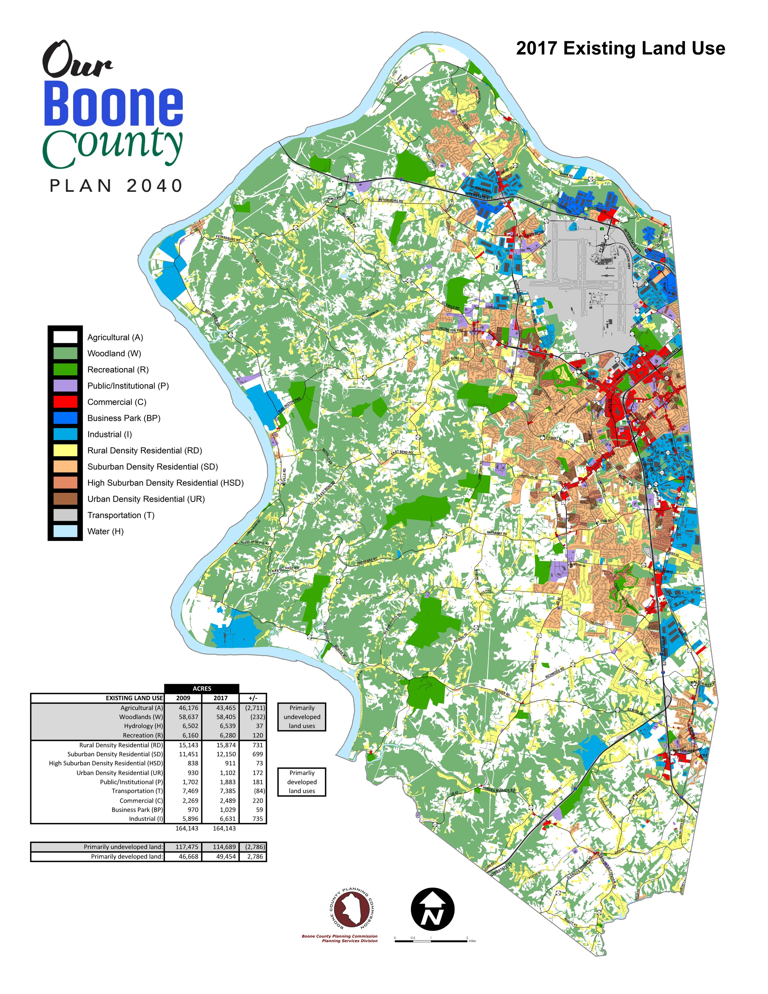
The existing and future land uses in Boone County have been identified in this element with basic classifications. These classifications, based upon the type and density of use, are described below. For the purpose of these land use classifications, density is defined as: gross density – the average number of units per acre for the entire acreage of a development. Except where noted, the classifications pertain to both the existing and future Land Use Maps.
Agriculture (A) (Existing Land Use Map only) – Agricultural activity and abandoned, overgrown fields that have not yet reverted to woodland, and vacant or future development areas within the urbanized portion of the county.
Woodlands (W) (Existing Land Use Map only) – Mature wooded areas of greater than one acre. In some cases it is pre-empted by established recreation uses on the map.
Rural Lands (RL) (Future Land Use Map only) – Wooded, agricultural, recreational, or low density residential uses of up to one dwelling unit per two acres. Residential construction in Rural Lands does not occur in a formal subdivision.
Hydrology (H) – Water, lakes, river.
Developmentally Sensitive (DS) (Future Land Use Map only) – Areas that have an existing slope of twenty percent or greater for a height of 20 meters (67.6 feet), or have unique soil or flooding characteristics which limit the ability of an area to support urban development, or contain significant wooded areas, creeks, wildlife habitat, or other natural features that are important to a site’s stability and visual character. In addition, developmentally sensitive areas may, in the future, be defined and protected due to historical or visual importance. Any development on land identified as Developmentally Sensitive must be carefully assessed by the developer and the Planning Commission to determine the ability of the land to support the proposed project. The land use priority for areas designated Developmentally Sensitive is preservation of the existing environment, as opposed to development of the land. This shall act as a guideline for any project proposed in Developmentally Sensitive areas; specific sites designated as Developmentally Sensitive require more detailed inventories of soil, slope, wildlife habitat, vegetation, and other possible physical constraints as part of the development plans. These inventories shall be used, along with engineering studies, to determine whether an area designated Developmentally Sensitive can be developed in a fashion which is sensitive to the existing site characteristics. The Developmentally Sensitive areas of Boone County have been identified by utilizing United States Department of Agriculture Natural Resources Conservation Service (formerly Soil Conservation Service) data and mapping, through the Boone County Geographic Information System (GIS). The degree of accuracy of these areas is intended to locate general areas of concern. Actual site assessments will determine the exact boundaries of Developmentally Sensitive areas in Boone County at the time of development.
Rural Density Residential (RD) – Low density residential uses of up to one dwelling unit per acre.
Suburban Density Residential (SD) – Single family housing of up to four units per acre.
High Suburban Density Residential (HSD) – Single-family and/or attached housing of up to 8 dwelling units per acre. This classification is typified by townhouse, condominium, and zero-lot line development, and also pertains to existing mobile home parks.
Urban Density Residential (UD) – Attached housing, generally condominiums or apartments, of over 8 dwelling units per acre.
Public/Institutional (P) – Government offices, schools, libraries, churches, cemeteries, fairgrounds, maintenance areas, etc.
Transportation (T) – Airports, major four lane roads, interstates, interchanges, ferries, and rest areas.
Recreation (R) – Public and commercial outdoor recreation including golf courses, parks, race tracks, private reserves, wooded areas that serve an established recreation use, etc.
Commercial (C) – Retail, corporate and professional office, interchange commercial, indoor commercial recreation, restaurants, services, etc.
Industrial (I) – Manufacturing, wholesale, warehousing, distribution, assembly, mining, and terminal uses.
Business Park (BP) – A mix of office warehouse, research, office, and light industrial uses in a park-like, office campus setting with large building setbacks, low floor area ratio, integrated pedestrian and recreation facilities, consistent architectural and signage theme, extensive landscaped areas, and attractive entrance treatment. This land use is recommended for high visibility areas and transition areas between industrial and residential land uses.
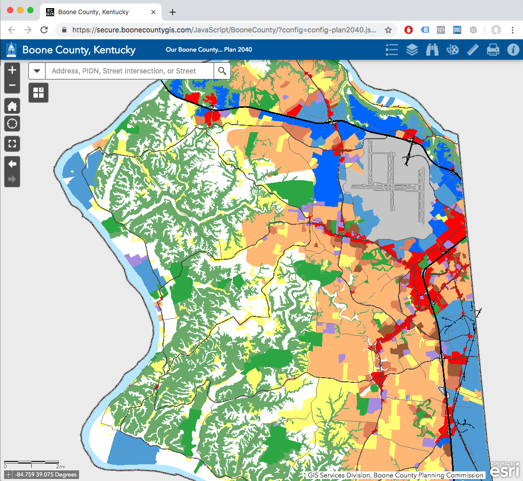
DESCRIPTION AND PURPOSE OF LAND USE MAPS
This Comprehensive Plan provides a 20-25 year outlook for land use, while zoning is typically treated as a five-year tool. The zoning map represents what immediate uses can occur on property based on infrastructure and other considerations. The Future Land Use Map should not be used as a zoning map. In addition, unlike the zoning map, it does not portray land use regulations parcel by parcel. The Future Land Use Map is one tool used to guide the formation of zoning regulations.
A Future Land Use Map, projected to the year 2040, and an Existing Land Use Map, accurate through 2017, have been produced with the Boone County Geographic Information System (GIS) and are intended to be used in tandem with the accompanying text in this chapter per the respective geographic areas descriptions included on the following pages. In addition, the recommendations contained in the following geographic area descriptions are the result of the culmination, review, and analysis of information contained in the previous chapters of this document. The individual elements/chapters of the plan are pulled together and considered when composing the conclusions and recommendations for each individual area, Boone County as a whole, and the Northern Kentucky and Greater Cincinnati region.
The area breakdowns are provided to allow for ease of use in finding text for specific areas of the county. The Future Land Use boundaries are intended to be approximate and subject to refinement and interpretation by the Planning Commission and county legislative bodies. It is important to consult the Land Use Element text to learn of timing or phasing issues that may be present in a particular area. The Future Land Use Map may indicate future land uses for a particular area, however, the area may not be ready for development until certain infrastructure is in place or another area develops first. It is critical to note that the Future Land Use Map is a projection to the year 2040, and is not necessarily intended to commit areas to development immediately. In some areas, phasing may be used to make sure development is supported by infrastructure, and in others, development may be delayed until planned infrastructure is provided.
This Comprehensive Plan recognizes that there is much coordination that occurs between the Planning Commission, state and local governments, utility commissions, school districts, the development community, emergency services, public works, recreation departments, transportation agencies, and numerous other public services whenever a land use or infrastructure decision is reached. Primarily, this existing process involves direct contact with affected groups during zoning map amendment reviews. This process is beneficial to correlating land use and infrastructure provisions and should be reinforced. Groups providing these services should consult the Future Land Use map on a periodic basis and whenever they plan for future infrastructure needs and improvements. Since the Planning Commission administers land use regulations, but does not control infrastructure improvements, it is critical that groups that do provide public facilities and services participate in the public review processes such as zoning map amendment reviews. If this becomes difficult, then a revised system may be needed in the future.
Future Land Use Geographic Areas
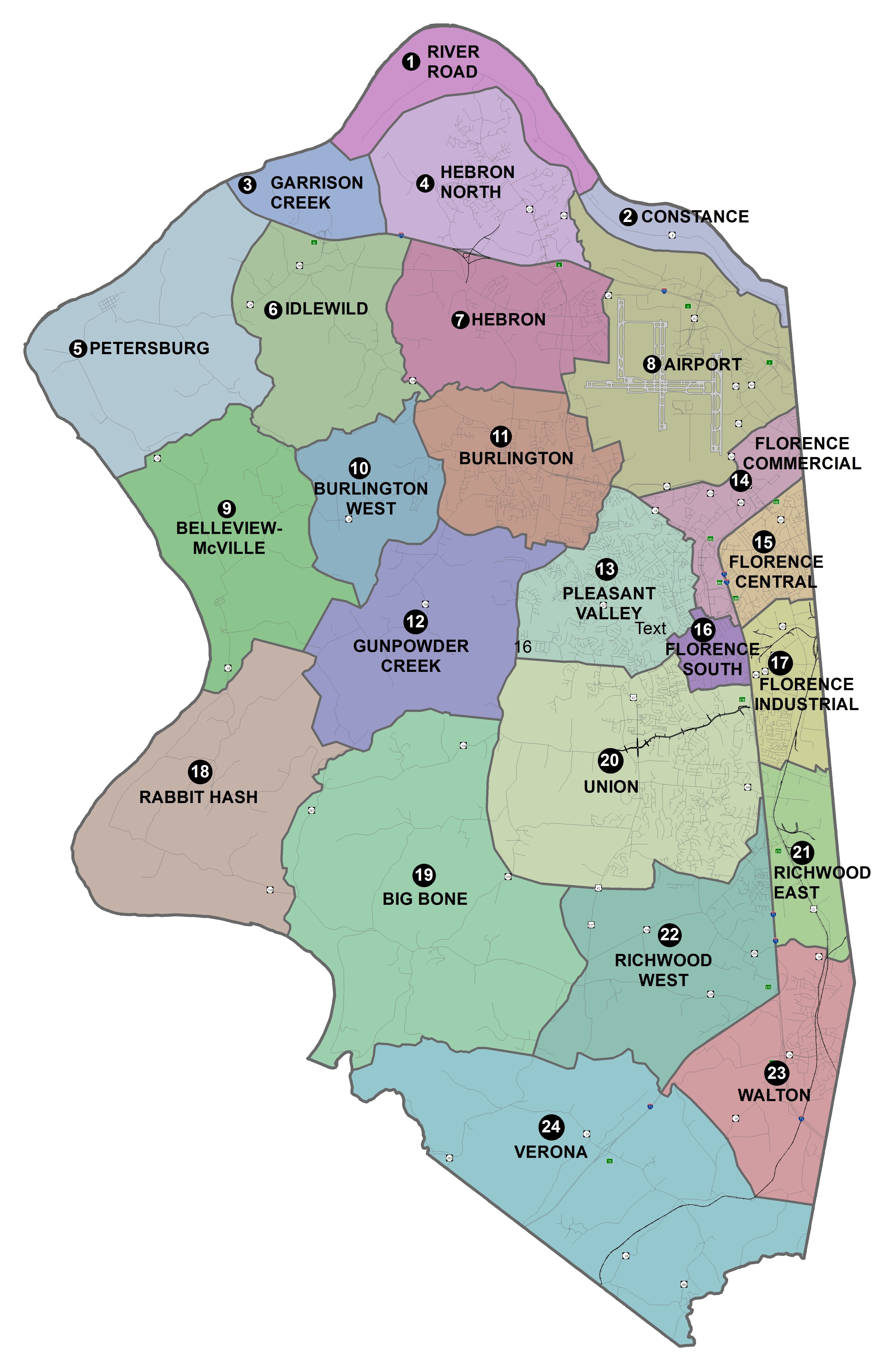
CONCLUSIONS AND RECOMMENDATIONS
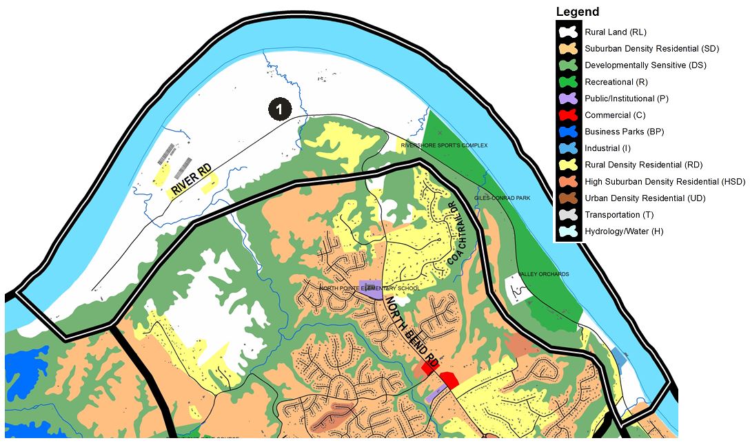
1) RIVER ROAD
This section of Boone County is bound to the north by the Ohio River and includes much of KY Route 8 (River Road) from near Elijah’s Creek westward to just beyond the end of the road and is bound to the south by the hillsides that lead up to the Hebron area. Along with significant Ohio River frontage, this area is characterized by rolling topography and Developmentally Sensitive hillsides.
Because of the sensitive nature of these hillsides, they should remain wooded. The Ohio River bottoms contain agricultural land and should remain in that capacity. Since the area is scenic and its roadways do not readily serve large amounts of development, very limited Rural Density Residential growth should occur along KY 8. Some specialized agricultural uses should continue in the Ohio River floodplain. The Natural and Cultural Resources Element of this plan indicates this section is suitable for recreation uses; new recreational uses are important because of the residential growth throughout Boone County. The current use of KY 8 by cyclists will likely continue and increase, and provisions for this recreational use should be considered as part of any future developments in this section of the County. Any connection of KY 8 to the I-275/Petersburg Road interchange could adversely affect this recreational use. Pedestrian and bicycle access to this area from Hebron should be explored. Overall, this section should experience limited development because of the many Developmentally Sensitive areas and poor access.
This section of Boone County has considerable Ohio River frontage, as well as an important residential development area along North Bend Road. Between Rivershore Farms and Taylorsport is a large river plain suitable for athletic fields and similar recreation uses, exemplified by Conrad Park as well as the Valley Orchards property which is a future active recreation park slated to include over a dozen soccer fields. Approximately 1,100 acres at the northern end of this River Road area are protected by private conservation easements held by the Hillside Trust and other organizations.

2) CONSTANCE
This area is bound to the north by the Ohio River from Taylorsport eastward to the Kenton County boundary. It is bound to the south by the Developmentally Sensitive hillsides that lead up to the airport area.
Below the hillsides, land uses in the Ohio River floodplain should remain agricultural, Rural Density Residential, or river related recreational. The western portion of this section of Boone County lies in the flight path of the 18-L north-south airport runway, with associated noise discouraging residential growth.
The river bottoms in the Constance area would make excellent recreation areas over the planning horizon as they have very limited development potential and should remain largely residential and agricultural in character, with occasional local commercial development. Although this area includes excellent industrial potential along the river, access is poor. Future industrial development may become appropriate should the access issue be addressed. The Anderson Ferry service should continue as a service to automobile, bicycle, and pedestrian traffic, and represents an historic resource for Boone County.
3) GARRISON CREEK
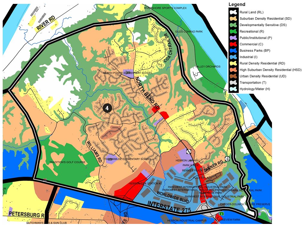
4) HEBRON NORTH
Acreage next to the interstate, at Graves Road, is appropriate for high-profile office uses in order to take advantage of the planned Graves Road interchange and to provide a transitional use between the business park development to the east and residential uses to the west. A road and sanitary sewer connection between the I-275/Petersburg Road interchange and Graves Road interchange warrants a land use/zoning study to determine feasibility and potential impacts. Limited Rural Density residential growth should occur along other roads in this section as further Suburban Residential development cannot be adequately supported by the existing road system without significant improvements to Williams Road.
Suburban Residential development should occur along the southern portion of Williams Road as a result of infrastructure improvements. With public sanitary sewer improvements in the Sand Run Creek and Elijah Creek watersheds, there will continue to be considerable growth pressures. Development should be clustered on the ridge top areas because of the limited capacity of the existing roadway network, the Developmentally Sensitive areas, and the importance of the stream valleys as greenbelts. Lower density development, such as Rural Density Residential, should provide a transition into the Developmentally Sensitive areas.
With the provision of adequate infrastructure, some Suburban Density Residential development and small amounts of attached housing may extend onto the ridge top areas. Development would need to retain the bluff line vegetation in order to minimize the visual and environmental impacts of residential development. Planned Development or clustered housing should be used to insure proper development of this area, due to environmental and site characteristics. Much of the remaining land in this section contains Developmentally Sensitive and scenic hillsides, and should stay wooded in order to create open space between future developments. The Sand Run Creek and Elijah Creek valleys should constitute such open space.
The area west of Traditions Golf Course should develop residentially, once adequate road access and utilities are available. This Residential development in and adjacent to Traditions Golf Course on Williams Road should not encroach on the developmentally sensitive areas.
Conventional layout subdivisions should be discouraged because of their inefficient circulation systems and excessive site grading requirements. The stream valleys and ridge bluff edges in this section should remain in their current state to provide public open space for the residential development on the ridge tops. Overall, this section should experience growth because of its proximity to I-275 and the Burlington-Hebron areas. In general, Suburban Residential development should be concentrated on land nearest to KY 237 and the Graves Road interchange as indicated on the Future Land Use Map.
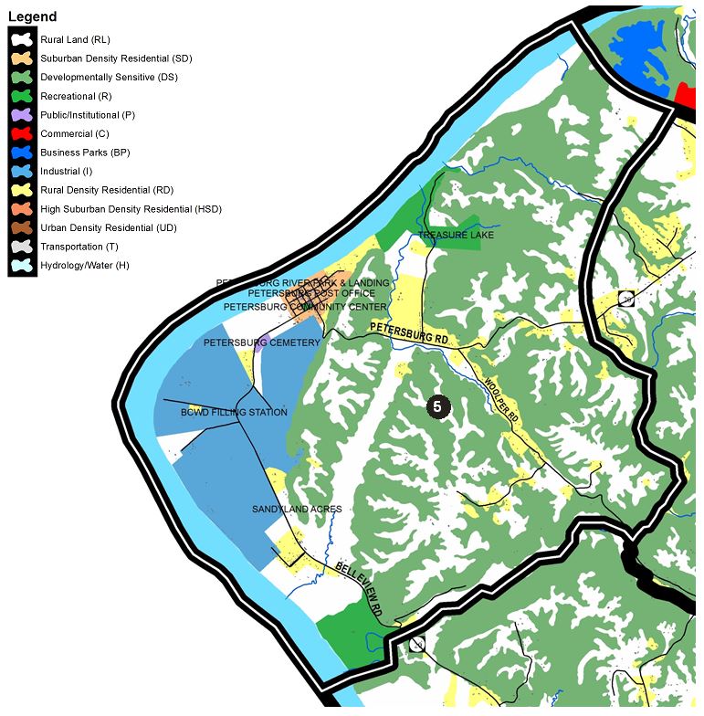
5) PETERSBURG
This section of Boone County, bound to the west by the Ohio River, to the north by I-275, to the south by the former Split Rock property, and to the east by the western-most portion of KY 20 and is characterized by the town of Petersburg. Much of the land is Developmentally Sensitive, undeveloped, or in agricultural uses.
Petersburg could potentially be a resource for heritage tourism in the county due to its history and river frontage. The extraction of gravel along the Ohio River in this area should continue at established sites but new locations for extractive operations should be discouraged so as to allow alternative uses, such as recreational and low density residential development. This should lead to an appropriate balance of uses along Boone County’s substantial river frontage, including access for recreational uses. Inactive sand and gravel extraction sites along the river should undergo the reclamation process described in the Boone County Zoning Regulations, or be converted into recreation opportunities. The land to the north of Petersburg should be maintained for eventual low density residential, and recreational uses. There are also sites of archaeological significance in this section of the county which should be identified and preserved. In fact, the entire town and river plain area surrounding it, have high potential for burial and village sites to be found by any type of modern construction. Public infrastructure installation and private construction needs to be done carefully and under supervision of knowledgeable authorities. The existing pay fishing lake area and Taylor Creek should be considered for a future wildlife habitat area. Development in the Petersburg area should protect the scenic characteristics of the hillsides and river plains.
Petersburg must continue to contend with its isolation from the urban service areas of Boone County and poor accessibility during the winter months. Any reconstruction of KY 20 into Petersburg should occur for the purpose of serving residential and school-related traffic, rather than for use by industrial vehicles. The preservation of the historical buildings of this important Kentucky town should be a prime objective, and eventual development of a tourist industry is possible with adequate planning and administration. Small commercial services within the town should be provided and designed to reinforce and retain the small town character of Petersburg, along with the Petersburg Community Center and branch library. The areas in and around this town offer an opportunity for neo-traditional residential and small commercial development. With improvements to KY 20 and the provision of water and sewer service, the town could grow significantly. For this to occur, it must be in the form of formal and well-designed neo-traditional development. Public water lines reached the southeastern edge of town in 2010, but have not yet been extended into the town grid.

6) IDLEWILD
This area is bound to the north by I-275. The east is bound by Sutton Lane and Dutchman’s Rod & Gun Club and following Woolper Creek down to Easton Lane which also serves as the southern boundary. The west edge is defined by Ashby Fork Creek and then to the west of Caribou Drive up to Second Creek and north to I-275 at the end of Stevens Road.
This section of Boone County contains the I-275/Petersburg Road interchange, Idlewild Road, and a portion of KY 20. Portions of the area have public water but lack public sanitary sewer, which affects projected land uses and development density in and around the interchange. The south side of the I-275/Petersburg interchange should experience highway related commercial growth as well as services for residents living in the area and tourists visiting the Answers in Genesis Creation Museum. This growth is likely to occur on the southern half of the interchange because of easy access to the interchange and availability of relatively flat land. In addition, a mixture of office, retail, business park and residential uses are recommended on the west side of KY 20 and south of I-275. Access to future Commercial, Business Park and High Suburban Density Residential uses in the southwestern quadrant must align with Bullittsburg Church Road. Bullittsburg Church Road should be improved to support additional traffic from the existing museum and future commercial development. The existing concrete plant site should eventually be redeveloped as office or retail uses. The wooded swale south of the plant site should remain as a buffer to existing and planned residential uses in the area to the south.
Continued and gradual Rural Density and Suburban Density Residential uses should occur along KY 20 between Idlewild Road and Bullittsville. Street connections between KY 20, Idlewild Road, and through interconnecting subdivision developments are to be provided where possible. It is recommended that the Idlewild Road area, in and around the year 2026 65 DNL contour level, continue as Rural Lands. This section could be impacted by the proposed I-275/Graves Road interchange and increased night time air cargo flights from the Cincinnati/Northern Kentucky International Airport.
Overall, any future development in this area should include an attractive and efficient mixed-use development with consideration to impacts, building architecture, site planning and landscaping. Development should also consider and embrace the area’s historic and cultural aspects. The High Suburban Density Residential classification shown on the Future Land Use Map along I-275 is dependent on a new interchange in the Graves Road area and must be accessed from the interchange and Industrial/Business Park development described in the Hebron area and use section.
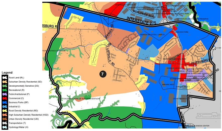
7) HEBRON
This section of Boone County is bound to the north by I-275, to the east by the Cincinnati-Northern Kentucky International Airport (CVG), to the west primarily by Woolper Creek and Dutchman’s Rod & Gun Club, and to the south mostly by a tributary of Woolper Creek that intersects England-Idlewild Park. This area includes the south sides of the I-275/KY 237 interchange and the proposed I-275/Graves Road interchange. The area also includes the town of Hebron and the Conner High School campus.
Subdivision activity should continue around Bullittsville and along Bullittsville Road, with High Density Suburban Residential on the north side of Petersburg Road near the proposed Graves Road Interchange. Residential development proposed to access the I-275/Graves Road interchange area must be accompanied by improvements to the surrounding road network. As mentioned in the Hebron North section, a land use and zoning study of this interchange area would be wise in determining its future impacts on land uses and the transportation network.
Additional business park development should occur west of Litton Lane and continue beyond the new Graves Road Interchange. A collector roadway should be developed along the south side of I-275 to provide access from the industrial property to the future interchange at Graves Road. Industrial developments should be designed to direct truck traffic to collector roads and away from KY 20. The Industrial/Business Park shown along the south side of I-275 in the Bullittsville area is tied to the completion of the Graves Road interchange. This development must be sensitive to the residential properties located to the south and should be accessed from the interchange and not via KY 20. This development must also be designed to fit into an established residential corridor. Design control will be important in this area. The existing and planned residential areas located on the east and west sides of KY 237, north of KY 20, should remain, with an area of commercial uses around the KY 20 and KY 237 intersection to serve local development.
The southeast quadrant of the KY 237 interchange should develop in a Business Park manner on the acreage fronting on KY 237. The design of this development should include large building setbacks to be visually consistent with existing development on the southwest quadrant. The site is suitable for a Business Park or one large user similar to the existing industrial uses located along Litton Lane. Property to the east of the interchange, along I-275, possess high visibility and is a suitable location for high-profile Business Park development similar to that occurring at the Mineola interchange. The development of this Business Park area is dependent upon a road connection from KY 237, opposite Litton Drive to Elijahs Creek Road to allow all traffic associated with the development to directly access the KY 237 interchange, and to serve future residential growth. This road should be connected to KY 20, near I-275 and near the runway tunnel, through industrial development. For industrial development to occur east of Elijah’s Creek in this area, it must have either the direct KY 20 connection or the KY 237 connection described above. Industrial traffic should not utilize Elijahs Creek Road unless that road is significantly upgraded for its entire length.
High Suburban Density and Urban Density uses in Hebron should remain near the intersection of KY 20 and KY 237. These uses must have adequate water and sanitary sewer service and should be accompanied by increased school capacity. These developments should utilize existing woodland as a buffer to the Suburban Density Residential uses. The small industrial park surrounding the Hebron Post Office should continue to develop to the limits indicated on the Future Land Use Map.
The property adjacent to the former Public Library, on the north side of Cougar Path, should develop as various, clustered public facilities, and/or compatible commercial and office uses, to make use of the easy access to Hebron-Burlington-North Bend Road service areas. The former Lents Branch Library site itself should develop with commercial, office, or retail uses and have its access off Cougar Path.
The KY 20 and KY 237 intersection area should contain a variety of commercial and higher density residential uses to establish the location as a future service center connected to the older town of Hebron. Open space and landscaping should be an integral part of development design at this important Boone County intersection to give the appearance of coordinated development. Further Urban Residential uses planned behind the Hebron Commercial Mart development must utilize a site design that pays attention to building orientation and landscaping in order to enable an adequate visual transition from KY 20 and into older single-family areas to the north. These established residential neighborhoods will eventually be surrounded by commercial, industrial, and higher density residential development, and need some degree of visual protection. The commercial uses at this intersection should be consistent in architectural design and landscaping with adjacent residential uses. The planned Urban Residential uses should not develop until adequate elementary school space is available. Small roads in the area are not suitable for serving subdivision or industrial traffic and must be upgraded or bypassed in such developments.
Due to the impacts of aviation noise, industrial uses are recommended on the east side of Limaburg Road. A substantial land area is located in the east-west flight path, extending west of KY 237 to Bullittsville Road, and is suitable for Business Park development. No industrial access should occur to Bullittsville Road. The north side of Conrad Lane, shown as Industrial, should contain an extensive buffer area to protect the developing residential subdivisions to the south. The recently released 2026 Noise Exposure Contours (65 and 70 DNL) show very little change to the west from what has been anticipated in previous Comprehensive Plan updates and will not affect the Future Land Use patterns in this area.
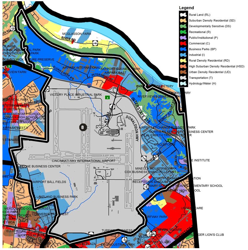
8) AIRPORT
This section is bound to the north by the Developmentally Sensitive hillsides north of I-275 that lead down to the Ohio River bottoms and is bound to the west by Elijah’s Creek. South of I-275, the eastern boundary is formed by Airport property to KY 237 at Conrad Lane, then south along Limaburg Road to just north of the Golf Ranch, along the back of Commerce Park West to Gunpowder Creek. The southern border is defined by KY 18/Burlington Pike from Gunpowder Creek to just west of Centennial Drive where it then follows the Aero Parkway corridor to Turfway Road which it follows to the Kenton County line, which forms the eastern edge of this area. The area completely contains the Cincinnati-Northern Kentucky International Airport (CVG) as well as the I-275 interchanges at KY 212 and Mineola Pike. Major developments within this section also include the Airport Exchange Business Park, Circleport I and III, the Mineola Industrial Park, and the proposed Amazon development along Aero Parkway.
This section of the County should experience substantial growth. To the north, the Mineola interchange area should continue to experience Business Park development, although the amount of land yet to develop in this area is running low. On the south side of I-275, Circleport Industrial Park still has some acreage to develop. Residential uses along Mineola Pike and Booneland Trail should eventually be redeveloped in a Business Park manner, similar to the adjoining uses. Rolling Green Acres should likewise eventually redevelop as Industrial uses. Because of increasing development, the road network in this section should be improved, including the widening of Mineola Pike and road connections across airport property to KY 18 and/or Limaburg Road. The Cincinnati/Northern Kentucky International Airport is considering alternative plans to construct a new north south runway in this area to operate as a pair with the existing 18L/36R runway. The new construction would be east of the existing runway, and therefore would require the relocation or displacement of Donaldson Highway, Mineola Pike, O’Hara Road, and Turfway Road, as well as existing industrial developments, a church, some low density residential uses, and a portion of the Turfway Racetrack operation. If this concept becomes a reality, a joint Airport/Boone County/City of Florence land use study needs to be conducted to properly plan this area.
Riverview Estates Subdivision and the residential area on Hunter Drive and Hetzel Drive should eventually redevelop into industrial uses to take advantage of the proximity to the interstate. The existing Bluebird Subdivision should remain residential and not experience piecemeal conversions to business uses. Future business uses may be appropriate if residential to business conversion is proposed on all of the subdivision area. The existing commercial parking lot facilities at KY 20 and KY 212 should eventually redevelop into office, hotel, convention, and travel related commercial uses. Commercial parking uses should be relocated onto airport property, in closer proximity to the airport terminals. Industrial development to the north of KY 20 should not locate on any portion of the Developmentally Sensitive hillsides, and a buffer area for the preservation of those hillsides may be required. Throughout these hillside areas, stands of existing trees should be retained between individual developments.
Along Point Pleasant Road itself and adjacent to I-275, some office development, consistent with the Airport Exchange Business Park, is appropriate. Traffic associated with this development should be directed toward the interstate. All development in this section must be carefully designed to minimize impacts on the Developmentally Sensitive hillsides, which should remain mostly wooded. Since the ridge top areas are also heavily wooded, the design of office and residential development should incorporate existing stands of trees.
Land to the north of Elijah’s Creek Road, including the plateau area known as the Shor Property, should be developed in a Business Park fashion. Access to this area should be by a road connection to KY 20, through Airpark International, and may eventually include a connection to KY 237 at South Park Drive, along the I-275 right-of-way. Access to this area directly from Tanner Road or Route 8 is not desirable due to geologic formations, topography, vegetation, and scenic views. In its current condition, Elijah’s Creek Road is not suitable for serving additional traffic. The road should be further improved to allow access to the Shor Property and permit redevelopment of the existing residential uses. Development of this area must be carefully planned, with great care taken in preserving and protecting the surrounding Developmentally Sensitive hillsides and existing vegetation clusters on the site. This will necessitate creative design and construction techniques, sensitive location of buildings, as well as the retention of existing vegetation along the bluff edges.
Planned Business Park development on Conrad Lane east of KY 237 should be accessed through industrial development to the north and not contain access to Conrad Lane, unless Conrad Lane is connected in the future to Aero Parkway to the east. Due to the existing aesthetic qualities of this area, including rolling topography and stands of mature trees, the industrial development of this area should incorporate these features into planned site designs. In particular, existing areas of mature woods should remain intact to retain the character of the KY 237 corridor and provide a transition into adjoining residential areas.
The construction of Aero Parkway opened up over 1,000 acres for potential industrial, office, and commercial development. Amazon will begin constructing its Prime Air hub on the north side of Aero Parkway in 2019 with plans to open in 2021. A coordinated planning approach to developing this corridor will assure quality development, proper expansion of infrastructure, and new employment growth. This includes detailed analysis of the proposed effects on the transportation network in and around the Aero Parkway area as it develops into a heavy logistics corridor.
Planned commercial and industrial development may be supplemented by other land uses along the north side of KY 18. However, all development must be interconnected, and connections must be provided to Aero Parkway as opposed to utilizing Old Limaburg Creek Road for primary access. The plan also recommends a roadway extending west from Aero Parkway to the KY 237/Conrad Lane area. The primary function of both roads should be to move traffic through the area, not to serve as access for adjoining parcels. Limaburg Creek Road is inadequate to carry industrial traffic and intersects KY 18 at a dangerous location. The Future Land Use Map indicates a mixture of land uses along the KY 18 corridor, which will provide a transition into existing and planned public facilities uses near KY 237.
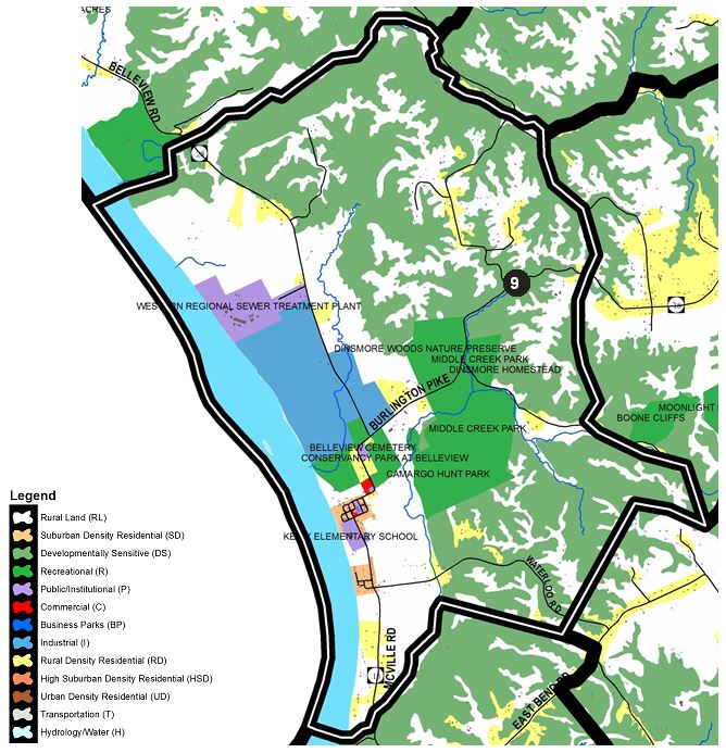
9) BELLEVIEW/McVILLE
This section is bound to the west by the Ohio River and to the north by Woolper Creek. The east edge of this area is just west of Woolper Road southward west of Boone Cliffs and includes much of the Middle Creek valley to just south of Waterloo Road where the southern boundary area includes the Ohio River bottoms to the intersection of KY 18 and Lower River Road.
The river bottoms in this section contain prime agricultural land and existing gravel extraction sites. New extraction operations should be confined to sites adjacent to existing operations between KY 20 and the Ohio River. The redevelopment of former gravel extraction sites may be suitable for river related recreational uses accompanied by self-contained clustered residential development. The hillsides should remain largely wooded, while the more level areas can continue to support agriculture. This area includes some of the county’s best farmland. The river bottom areas generally have poor road accessibility, although industries involved in processing bulk products could locate there to make use of river barge transportation. Future development or expansion of these industries should occur with sensitivity to the residential, recreational, and agricultural potential of the river bottom area, especially near Woolper Creek. Upon the disuse of existing sand and gravel operations, reclamation should occur.
During the late 1980s a combination recreation and residential development with a marina was started at the mouth of Woolper Creek and, after the project was abandoned, the Corps of Engineers conducted a partial reclamation of the site. The result has been the creation of a significant wildlife habitat that should ultimately become accessible to the public. This site has been shown in past OKI, NKADD, and Boone County recreation studies as suitable for a large county park or similar facility, and constitutes another potential resource within the western Boone County tourism area. Adjacent to the former marina site is the geologically significant formation known as Split Rock. The Woolper Creek Watershed Initiative was completed in 2016 under the direction of the Boone County Conservation District. The final report includes inventories, analyses, and recommended Best Management Practices for the 33-square mile Woolper Creek Watershed. Additionally, a study should be conducted to consider the Woolper Creek Valley as a recreation/ environment preservation corridor.
Sanitation District No. 1 (SD1) of Northern Kentucky’s Western Regional Wastewater Treatment Plant south of Woolper Creek went online in 2012. SD1 intends this plant to serve the developing portions of Boone and Kenton Counties, although some of the Petersburg-Belleview area may be able to access the plant with private infrastructure and necessary approvals. Overall, the plant is not intended to encourage growth and development of this portion of the County. Because of the geological and natural resources present in this area, there should be some public recreation opportunity associated with the plant location and the service lines and easements that lead to the plant.
This section of Boone County contains the small communities of Belleview and McVille, and is primarily composed of river bottom area. The gravel extraction operations to the north of Belleview should remain, but should not extend east of KY 20, or adjacent to existing or planned recreation sites. The southern portion of this area, where mineral extraction has been concluded, should be considered for development as a river oriented recreational area, or wildlife habitat as part of the reclamation process.
Belleview and McVille proper should function as neighborhood centers for the surrounding area. The communities in this general area of Boone County have experienced some growth, in the form of the Kelly School in Belleview and the firehouse. Additional new local-scale commercial services may develop; existing buildings should be restored or replaced to meet the towns’ residential and commercial needs. The cemeteries on KY 18 will hinder any development in that area, thus any growth should occur south or east of the towns. Overall, this section should experience slow residential growth along the major roads of the area, with neo-traditional residential or continuing agricultural uses on the river bottoms. Any commercial development in this area should occur within the town centers of Belleview and McVille and not along the roadways outside the towns. These two towns present an excellent opportunity for residential to expand in a neo-traditional manner, as described for Petersburg. This development must carefully be carried out so that typical subdivision development does not alter the character of the area. With proper development in this fashion, the towns can become centers of activity for western Boone County.
The Middle Creek Valley comprises a major portion of the land area in this section. Substantial acreage is Developmentally Sensitive. It should remain mostly wooded to protect historic and recreation uses in the area from the visual impacts of nearby residential development. Boone Cliffs is also located in this area and contains important geological formations which should be preserved. Additionally, this section contains the Dinsmore Homestead, Boone Conservancy, and three properties maintained by Boone County Parks, including the 75-acre Boone County Cliffs Nature Preserve, the 105-acre Dinsmore Woods Nature Preserve, and the 230-acre Middle Creek Park. These sites should likewise be preserved as they are valuable assets. The Middle Creek Valley should become a preservation corridor in order to protect and expand the existing nature preserves, passive recreation sites and historic sites. This area should be protected from major utility main construction, such as water and sewer, and from development pressure along KY 18, including extractive mining activity. KY 18 is the major access route to the area and needs moderate improvements to accommodate traffic without jeopardizing the region’s rural characteristic. Boone County, private organizations and the citizens of the county should work together to insure that this important area is protected. Outside of the towns, this section should experience isolated growth of a Rural Density Residential character.
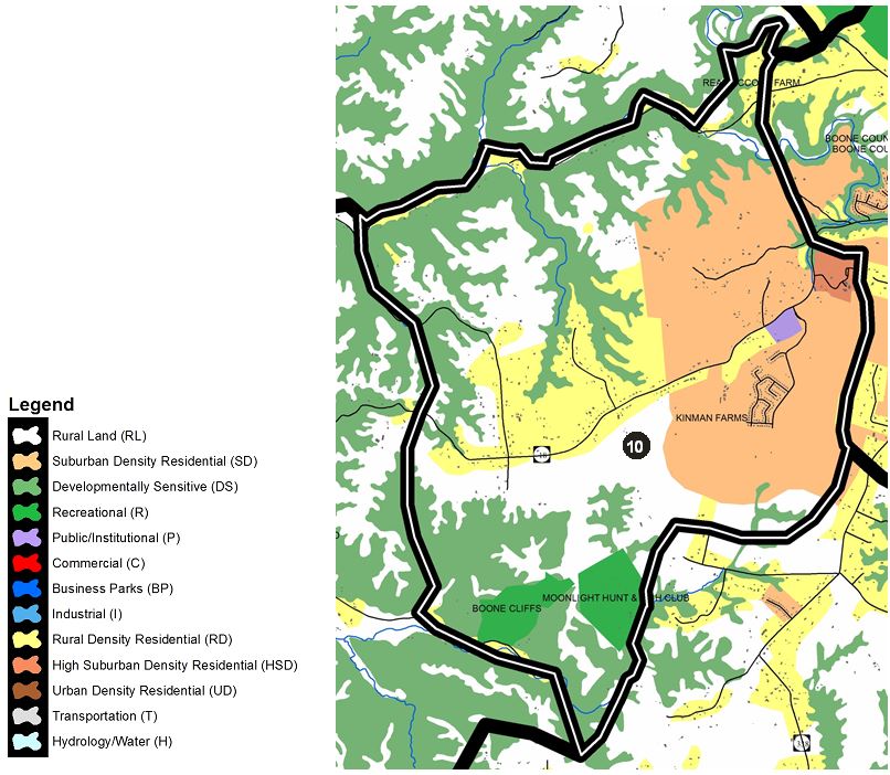
10) BURLINGTON WEST
This section is defined to the north by Woolper Creek, to the east just outside of the developing region west of downtown Burlington near Griesser Farm southward including Hunter’s Ridge. The southern boundary is defined just north of Possum Path and then southward along the east edge of the Moonlight Hunt & Fish Club to Middle Creek. The west boundary begins just west of Boone Cliffs up to Woolper Creek. This area contains parts of the Woolper Creek valley and the extensive Developmentally Sensitive areas associated with the creek. It is also part of the Woolper Creek Watershed Initiative area. This area should nevertheless experience some population growth as the Burlington area continues to change from a rural community to a suburban community.
Parts of the Woolper Creek valley should be preserved and included as part of the tourism/recreation potential of the area. To provide an appropriate entrance to the potential large western Boone County tourism area, KY 18 west of Burlington should maintain a rural appearance through unique subdivision design. As this area develops and anticipated school facilities are built, improvements to KY 18 will be needed, such as shoulders, reconstructed curves, improved sight distances, and sufficient intersection improvements in Burlington at KY 18 and KY 338. Suburban Residential Land Uses depicted on the 2040 Future Land Use Map in this area should not be developed until these conditions on KY 18 are improved, and adequate school capacity can be provided in the area. The balance of land in the western part of this section should remain largely undeveloped or agricultural uses, and suburban development should stay in the immediate watershed of the KY 18 sanitary sewer pump station. New residential subdivision development in the KY 18 corridor west of Burlington and east of Woolper Road should be designed carefully to respect the rural character. As the Future Land Use Map indicates, the planned Suburban Residential land uses west of Burlington change in this corridor to Rural Density, Rural Lands, and Developmentally Sensitive further west. Future Suburban Density Residential development in this area needs to provide sections of lower density residential adjacent to these areas. A true density step-down is needed beyond the frontage and setback transitional recommendations described in the Development Guidelines section of this element. Subdivision entrance areas and frontages along KY 18 should also be sensitively designed to retain the rural character of the area.
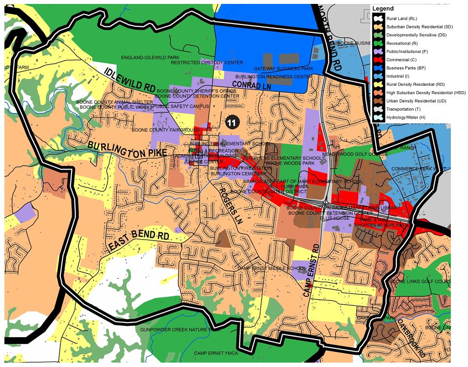
11) BURLINGTON
This section of Boone County contains Burlington, part of KY 237, and KY 18 from Shady Hollow Lane to Gunpowder Creek near Limaburg Creek Road. The area’s western boundary traverses just west of Emerald Drive and Saddle Ridge Drive and northward past Woolper Creek to just north of Easton Lane. The northern boundary is defined by Woolper Creek eastward to KY 237. The east boundary consists of KY 237 southward to Conrad Lane and then east to Limaburg Road south and includes the Golf Ranch and Commerce Park West. The south boundary is defined by the north edge of both Gunpowder Creek Nature Park and the Camp Ernst YMCA.
KY 18 and KY 237 are important roads to all of Boone County. The primary function of these roads is to move traffic through the area, with direct access to specific properties being a secondary function. 2020 will see the completion of the 3rd phase of upgrades to KY 237 from KY 18 to U.S. 42 and will significantly improve traffic flow into and out of the southeastern portion of this area. Intersections along KY 18 should continue the existing pattern of spacing of major access points of at least 600 feet. A parallel roadway network should be developed to provide access to properties fronting on the roadway.
Central Burlington includes a National Register Historic District and will continue to experience growth-related pressures, primarily with infill opportunities at a small scale in and around the town proper. These small infill developments should make every effort to imitate and mirror the design of the buildings immediately around them with an emphasis on accentuating the historic character of the existing Burlington architecture. Historically important structures should be protected from development pressures or be subject to appropriate adaptive re-use to retain the character of central Burlington. This approach is encouraged in historic Burlington by a limited design review process adopted in the Boone County Zoning Regulations. As Boone County grows, there will be a greater need for public facilities and services. The 2002 Burlington Town Strategic Plan addressed the unique transportation, parking, public facilities, historic preservation, and residential characteristics of the area. The Boone County Justice Center and the Boone County Public Safety Center Complex have reinforced Burlington as the hub of local government activity. Some private investment, mainly in restaurant and shop uses, as well as the TEA-21 Transportation Enhancement Grants for sidewalks has continued the momentum for investment in the town center. In addition, the Ferguson Community Center at the renovated Historic Boone County Courthouse, which opened in 2017, and an outdoor plaza across from the Administration Building slated to be completed in 2019 offer new opportunities for public gatherings and events in town. Appropriate architecture and placement of new or renovated buildings is critical to respect the established character of the town. The influence of residential subdivisions in the surrounding areas, and the associated traffic, will necessitate improved traffic controls and management, particularly at KY 18 and KY 338.
The developing residential area south of KY 18, west of Oakbrook Drive and east of Camp Ernst Road must include street connections that enable traffic generated by the area to travel in all four directions. This should allow Oakbrook traffic to proceed to KY 237 in the Rogers Lane area, and Shaker Run traffic to access KY 18 without traveling on Camp Ernst Road or Oakbrook Road. Development in the area around Rogers Lane should be carefully planned. The remaining portions of this section of Boone County should develop in a Suburban Residential fashion, with the exception of planned High Suburban Density Residential uses between Hickory Hill Subdivision and KY 18. Subdivision street connections are vital to this area around Burlington to give alternative routes for residents.
The south side of KY 18, between Camp Ernst Road and Burlington, should develop in a mixed residential and commercial fashion compatible with Camp Ernst Middle School. Commercial uses should be of a local service variety and should be evaluated as to traffic generation, visual impact and buffering. Strip commercial development should not occur, rather an innovative mixing of Office, High Suburban Density Residential, Urban Density Residential uses, and some local commercial uses should be provided. Extra care must be taken when commercial property develops along KY 18 to ensure that the impacts on residential behind it are minimal, especially the former nursery and landscape supply property behind O’Reilly’s Auto Parts on Kingsgate Drive as the impacts of the prior use were minimal on the homes in Kingsgate Subdivision that adjoin it.
All development along the south side of KY 18 toward Burlington must use Access Management, including parallel roads, shared curb cuts, and adequate turning-lane provisions in order to maintain safety on this high volume route. This area provides another excellent opportunity for Suburban Density Residential and employment uses due to the Single Point Urban Interchange (SPUI) intersection at KY 18 and KY 237 becoming a major crossroads in the county.
The suburban growth around Burlington will be substantial, causing KY 18 and Idlewild Road to serve as higher volume collector roads. New subdivisions should locate in close proximity to Burlington proper. Any new subdivisions should develop internal road networks rather than using the existing roads as primary access; this will avoid congestion and allow adequate space for necessary road improvements. Road connections between KY 18 and Idlewild Road, between KY 18 and East Bend Road, and between Idlewild Road and Bullittsville Road should be made. The area west of Bullittsville Road within the year 2026 65 DNL noise contour level can continue to contain some Low Density Residential as well as Recreation uses. New construction within the 65 DNL noise contour should only occur if the residential structures are adequately sound-proofed. This impact would have to be completely restudied if the airport ever proposes any additional east-west runway configurations.
The possibility of east-west alternative runway construction by the airport would profoundly affect this area, requiring the acquisition of several significant residential neighborhoods. It would also affect three existing schools, several county offices including the new safety complex, and impact a National Register Historic District. The area road system, including KY 237, Limaburg Road, and any connecting routes to the future South Airfield Road would be interrupted.
The intersection area of KY 18 and KY 237 is a high visibility area that already has an office orientation. Because of the central location, the importance of the area, and the urban nature of the road system, this area is more suitable for a mix of office and commercial. Proposed development at this high visibility, central location should not be all retail, and should be comprised of mixed-uses including multi-family housing. A developer that proposes this concept on the northwest corner must show that it fits with the school uses near the site and does not create traffic issues in this area.
The area bound by KY 18 to the south, KY 237 to the west, Limaburg Road to the east, and Conrad Lane to the north currently contains a variety of land uses. This area should continue to develop in a residential fashion, providing low to high density housing opportunities. The remaining 9 holes of the Meadowood Golf Course could redevelop someday as a mixed use combination of Recreation and the adjoining Urban Density Residential and provide an east-west traffic and pedestrian connection between Limaburg Road and KY 237. The intersection of KY 18 and KY 237 should predominantly develop as an office-campus and institutional area with supporting commercial uses. Public Facilities uses should continue to develop at the southeast corner of the intersection. Much of this site has been developed as the Boone County Farmers Market and the Boone County Extension Enrichment Center. In the event of any future office or commercial development on the south side of Patrick Drive, the development design should seek to incorporate existing woodland as a transition into existing residential and church uses.
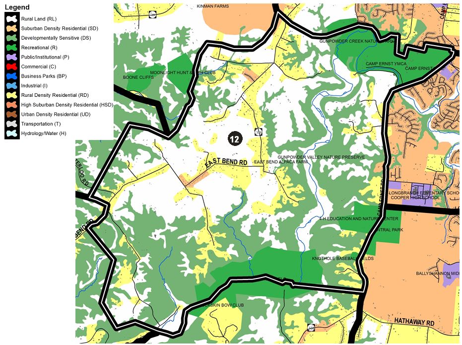
12) GUNPOWDER CREEK
The northern extent of this area includes Possum Path Road, Gunpowder Creek Nature Park, and the Camp Ernst YMCA property. The east is bound by Camp Ernst Road to its intersection with Hathaway Road. The south extents are defined by Gunpowder Creek as it crosses through Camp Michaels westward past Big Jimmy Hill Road. The west boundary includes land just beyond Beech Grove Road west of East Bend Road to Possum Path Road. This section of Boone County contains a substantial part of the East Bend Road corridor.
The greatest amount of growth in this section should occur along East Bend Road, mostly in the form of Open Space Design Residential development. The location and number of driveways should be controlled, and where possible, driveways should be shared. This development will require the realignment and improvement of East Bend Road. The small community of Waterloo may receive some limited residential growth as a result of growth in the Belleview and Burlington areas.
The Gunpowder Creek Watershed Initiative was completed in 2014 under the direction of the Boone County Conservation District. The study includes inventories, analyses, and recommended Best Management Practices for the 58.2-square mile Gunpowder Creek Watershed. The entire Gunpowder Creek valley should be considered for a future corridor study to preserve this unique and important County feature as a greenbelt and passive recreation corridor. Residential development should remain along the existing roads, consolidating access points where appropriate. An opportunity to reinvest in the Boone County Knothole property on Camp Ernst Road would provide much needed baseball and softball amenities in Boone County and compliment the sports facilities located across the road at Central Park.
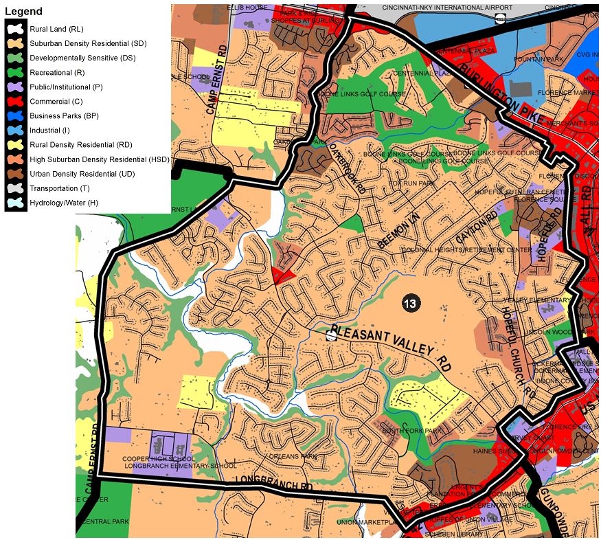
13) PLEASANT VALLEY
This area is bound to the north primarily by Burlington Pike (KY 18) eastward almost to the eastern intersection with Boone Aire Road and then behind the properties fronting on KY 18 to Hopeful Church Road. The eastern edge comes to the back of properties fronting on Mall Road and around the Ockerman campus. The limits continue along the back of properties fronting on U.S. 42 down to Pleasant Valley Road and then to U.S. 42 to Longbranch Road which serves as the southern boundary. Camp Ernst Road defines the west boundary from the south up to the YMCA property and then eastward to Gunpowder Creek which it follows north to KY 18. This section of Boone County includes some of the western growth areas of Florence, including Hopeful Church Road and KY 18. It also contains some of the recent residential growth areas from KY 18 south to Union.
Hopeful Church Road should continue to serve as a residential corridor. Some small scale neighborhood commercial services may be appropriate at a strategic location in the corridor. It should be scaled to serve the Hopeful Church Road and Cayton Road areas, designed with a residential-compatible look to the buildings and site, and without freestanding signage. Access management is important to avoid turning movement conflicts on Hopeful Church Road, and some road improvements may be necessary to support this development. Proposed commercial land uses on KY 18 should be planned with careful attention to Access Management, including continuous parallel roadways. Development should create commercial clusters rather than strip centers which parallel KY 18. These commercial uses must also be designed to be compatible with existing and proposed residential developments along KY 18.
The Rehkamp property on Pleasant Valley Road should develop in a Suburban Residential fashion in a Planned Development approach with mixed uses including varying housing types, local retail opportunities, all being served by local access and limited access collector road connections as a high priority. These should include a limited access connection of Pleasant Valley Road and Hopeful Church Road complete with a multi-use pedestrian path. These collector road extensions should not allow parking or driveway access in order to facilitate the movement of traffic through the area, and should include multi-modal elements such as pedestrian paths and bike lanes, and bus stop areas. The Pleasant Valley Road to Hopeful Church Road connector should be located and designed to serve large amounts of traffic.
Mixed-use development, that has commercial uses focused along U.S. 42 and varying types of residential uses, should occur southwest of its intersection with Pleasant Valley Road. The intensities of these commercial uses, in terms of building intensities, the size and style of individual structures, and the range of uses permitted, should begin with a broader range of commercial uses near the intersection and gradually decline to smaller-scaled office and institutional uses in the vicinity of Farmview Subdivision and the Florence/Union corporate boundary. Creative building layout and orientation should be used in lieu of strip-style commercial development, and Planned Development Overlay Districts should be utilized. All development in this area should be viewed as part of an entryway to both the Cities of Florence and Union.
The remaining portions of this section of Boone County should develop in a Suburban Residential manner. Major subdivisions in the area should provide internal connector roads with no driveway access or parking. Improvements to Fowlers Creek Road and bridges over Gunpowder Creek could provide connections from subdivisions along U.S. 42 and Pleasant Valley Road to the Longbranch and Camp Ernst Road area; these connections should be aligned with existing or planned intersections on U.S. 42 and the new Pleasant Valley Road to be constructed in 2019.
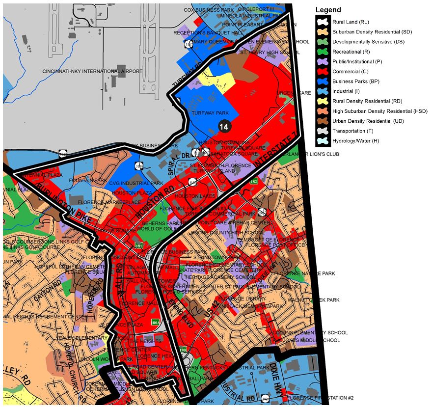
14) FLORENCE COMMERCIAL
This area is bound to the east by I-75/71 and the Kenton County line. The northern edge is defined by Turfway Road and Aero Parkway to Burlington Pike. The area follows Burlington Pike to include the commercial properties near the east intersection with Boone Aire Road and then south behind the properties fronting on Mall Road to U.S. 42.
A substantial portion of this section is located within the 2013 Houston-Donaldson Study area and has excellent development and/or redevelopment opportunity due to its high visibility from and easy access to I-75. Existing parcels should be developed/redeveloped to be aesthetically harmonious with existing surrounding land uses and cleaned up environmentally as much as is needed for new development. The property along Ted Bushelman Boulevard to Aero Parkway has developed as aviation or logistic industrial and should fill in any remaining properties in the same manner.
For the short term, the existing recreational use at Turfway Park should be maintained and improved. One way involves the expansion of the business into a “racino” if allowed by the State of Kentucky. If the horse racing business vacates the property, this site should be redeveloped in a mixed use format with a combination of Business Park and Commercial uses and connect to the Marydale site to the east. The 20 acre portion of Property located on the southern boundary of Turfway Park along Houston Road could possibly be developed as a commercial and/or entertainment use. Property across Houston Road from the Racetrack, along I-75, should develop in a mixed office and commercial manner compatible with the racetrack and entertainment operations.
Existing clusters of residential uses between O’Hara Road and the county line and along Donaldson Highway should redevelop in an integrated commercial fashion involving the combination of existing lots consistent with the Study. The central portion of the former Marydale property is recommended to follow the recommendations of the Houston-Donaldson Study, which calls for a campus-like mixed used development. A plan for extensive office development and some support commercial development has been approved for much of the site. Portions of the property near Turfway Road have been planned to develop in a High Density Residential nature.
The Mall Road area was recommended (through the 2002 Mall Road Corridor Study) to become a new urbanism corridor. The current planning effort for the area, the Mall Road District Study, calls for a dense, well designed urban style of development that should occur over time. Residential development may be a part of this urban area, but should be located to minimize noise impacts from the interstate and airport. The entire area of Steinberg Drive, Rosetta Drive, Connector Drive, and the I-75 Mall Road ramps should be planned in detail to provide mixed use development that includes a good road connection and traffic circulation between the Pleasant Valley Road corridor and I-75. Regionally-oriented growth should be confined to Mall Road and Houston Road, and should not expand onto U.S. 42, KY 18 or Hopeful Church Road. However, the highway-scaled, automobile-oriented appearance of this growth should be minimized through the provision of pedestrian improvements, smaller facilities within outlots in conjunction with larger strip-style centers, multiple, scattered parking areas in lieu of large central parking areas, and street trees along Mall Road. This growth should also include multi-modal transportation amenities, an idea which has been furthered by TANK’s transit hub on Mall Rd.
Commercial development in this section should remain near the arterial roads or close to the interstate. These consumer service and traffic-oriented developments must be contained to specific areas adjacent to the arterial roads and interstate. The coordination of curb cuts and parking lot connections in the already developed areas must occur in order to maintain a reasonable ease of travel along these roads. Undeveloped tracts of commercial land should connect to and coordinate with any adjoining commercial, office, or industrial development in existence. Where no development has yet occurred, provisions for Access Management must be made for future development. This includes the use of frontage roads as well as parking lot connections and shared curb cuts.
Attention must be given to the changing nature of retail and how it relates to the future of Florence Mall and other retail centers and stores. On-line retail continues to increase and the effect it is having on suburban malls, big box retailers, and other national retail chains cannot be ignored. Consideration must be given to how these stores may be able to reinvent themselves and continue as retail-based destinations that focus on experience-based shopping.
The visual appearance of commercial areas in general and of Mall Road in particular, should be enhanced through the design of buildings, landscaping, signs, and arrangement of buildings. Attention to aesthetic impacts of proposed developments should be part of all phases of the review process. The Mall Road District Study recommends a new direction for Mall Road that included the potential for more entertainment uses, high rise condominium, mixed use, and residential development. This is currently being implemented as part of the Mall Road District Study.
15) FLORENCE CENTRAL
This area is bound to the east by the Kenton County line and to the south by the Northern Kentucky Industrial Park. The west edge is defined by I-75/71 north to the county line.
The City of Florence developed from an aggregate of residential subdivisions, and is the main population concentration of Boone County. Florence did not develop in the traditional manner of cities, with established areas of concentrated commercial, industrial, and residential uses. Instead, the uses were intermixed. For instance, the city’s central business district is not in a precise location, but rather is a combination of suburban business districts. This factor, above all others, has molded Florence into a suburban city.
The City of Florence has a valuable asset in its Main Street area. The Florence Main Street Study, adopted in 1994, identified the uniqueness of this area and ways to improve its vitality and visual appearance. The goal was to transform Main Street into a pedestrian-oriented area. This was accomplished by the City’s commitment to rebuild Main Street, construct sidewalks, and install lighting. Efforts are currently underway to evaluate the progress being made in order to make the area more economically viable. This may include surveying historical structures, expanding the study area, adding parking, and make road, sidewalk, and lighting improvements. The result would result in a more cultural and historical setting and a mix of uses and businesses including entertainment and public spaces for events and activities. Recommendations will be offered to possibly amend the Florence Main Street zoning district to add more flexibility in the types of uses as well as encouraging good building design to reinforce the area’s character and diversity of uses.
The former Florence Nursery site (currently owned by the City of Florence) next to the Florence Senior Center has redevelopment potential as a location for an enlarged Florence Branch Library or some other public use. Development along U.S. 42 from Mall Road to the Ewing Boulevard area should continue to be a mixture of professional and local, traffic-oriented commercial activity. The area east of I-75, north of U.S. 42, and south of KY 18 shall continue to be developed in a cohesive manner to form a city center for Florence. The Parkway Corridor Study, which was originally developed for this area, was updated and replaced by the Central Florence Strategic Plan in 2008. The intent of this plan was to further develop the city’s central neighborhoods and to link existing and/or planned business, civic, recreational, entertainment, and residential attributes of the study area together to create a vibrant, inter-related city center.
As described in the Demographics Element, the condition of older housing in Florence should be specifically addressed. Florence should continue to enforce codes affecting the condition of properties in residential areas and in older business districts. Minimum standards are needed for building maintenance and design purposes. Higher density residential development should occur where it can serve as a buffer between industrial or commercial intrusion on single-family residential areas or where it is easily accessible. Overall, a mixing of uses can be accommodated within the City of Florence and the existing residential communities can be protected if proper buffers and design are incorporated into the developments. The redevelopment of property into commercial uses must be carefully designed in order to minimize impact of adjacent residential property. Any airport runway expansion in the future may have impacts on the existing residential areas of Florence.
In summary, growth in this section of Boone County must be balanced among three major land uses, commercial, industrial, and residential development. Growth in one land use must consider the location of existing and planned developments of the other two.
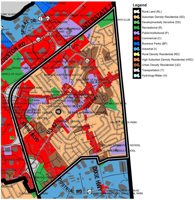
16) FLORENCE SOUTH
This area is bound by development along U.S. 42 to the north from its intersection with Mall Road south to the Old Toll Road area and then southeast along Gunpowder Road to Sunnybrook Drive and then bound to the east by I-75/I-71.
Vacant parcels and existing residences along the south side of U.S. 42 near Dilcrest Drive and Bentley Court may be appropriate for Urban Density Residential if the developer(s) can demonstrate that proper access management, architecture, and buffering can be provided. An extremely well-designed, low-impact professional office use may be considered for this area. However, the potential developer must submit detailed buffering and building design plans, and demonstrate that the project would establish a positive focal point for the U.S. 42 corridor in addition to minimizing visual, traffic, and stormwater impacts on adjacent residential uses. All developments must provide for connecting parking lots or a frontage road. In addition, right-turn lanes may be required for each development. Due to the high visibility of the lots and the need to minimize traffic distractions, minimal signage is recommended.
The area south of the Saddlebrook Farms Subdivision, along Weaver Road, has developed in an Urban Density Residential manner consistent with this subdivision, with adequate buffering for adjacent to single-family residential uses. The expansion of sanitary sewer lines on Evergreen Road will serve infill sites as well as those who are not currently on public sewer. Commercial uses should not expand along the west side of the interstate beyond the self-storage facility. The Lion’s Park site should remain as a recreation area unless it redevelops as part of the 60-acre McEvoy property adjacent to it which is recommended for Suburban Density Residential. However, a combination of Suburban Density Residential and High Suburban Density Residential, such as senior housing, could occur if a traffic impact study is conducted to determine if the existing road network is adequate and if not, what roadway improvements would be necessary to handle any potential increase in anticipated traffic volume.
Vehicle stacking problems during rush hours and conflicting left turn movements have become significant problems along the U.S. 42 corridor between the Weaver Road/Hopeful Church and Pleasant Valley Road intersections. The new “jug-handle” intersection design for Weaver Road and U.S. 42 will hopefully address some of these issues. Frontage road and interconnecting parking lots are necessary here to allow vehicles to access existing and future traffic signals. Access to Weaver Road should be implemented through redevelopment of the former Boone Kenton Warehouse site and adjacent parcels as well as well-planned access to U.S. 42. If improvements are made to Gunpowder Road from U.S. 42 to Mt. Zion Road, more intense land uses could be examined for the property behind Wentz Drive as well as the possibility of having access to Gunpowder Road. If commercial development occurs in this area, it should primarily be accessed from U.S. 42. In addition, improvements to pedestrian access along Weaver Road should be a top priority of the State when making improvements to the road network.
The vacant parcel on Weaver Road between the Grammas strip center and the Weaver Road fire station should develop as a low traffic professional office use. This part of Weaver Road is not suitable for commercial driveway access. In addition, a connector road should be completed from Mt. Zion Road to Weaver Road along the west side of I-75. South of this area should remain Suburban Density Residential in nature. Existing tree stands should be preserved to establish the contrast of this area from the Northern Kentucky Industrial Park, and to decrease noise impacts of I-75 and the airport.
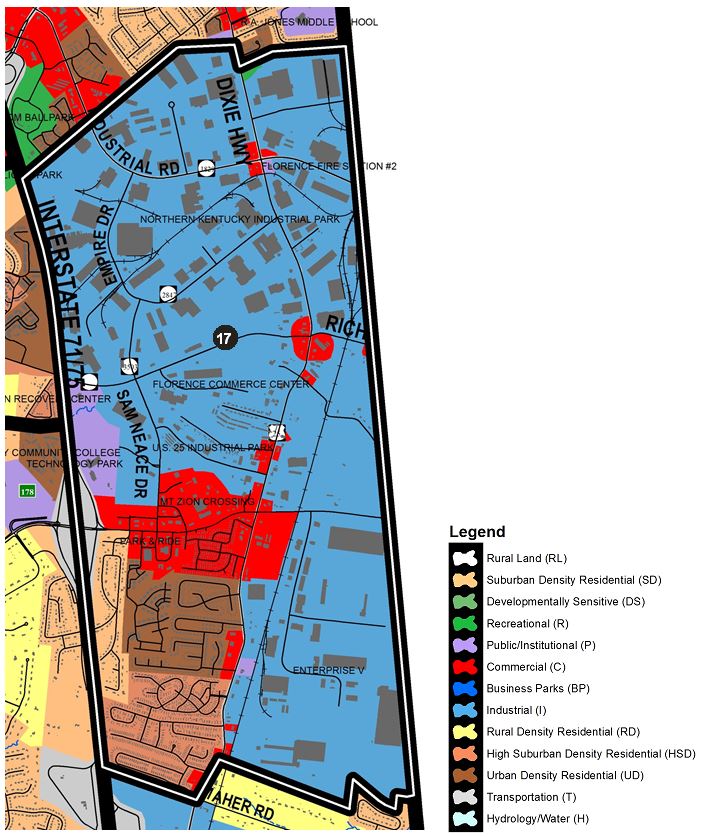
17) FLORENCE INDUSTRIAL
This area is bound to the west by I-75/71, to the east by the Kenton County line, to the north by the northern extent of the Northern Kentucky Industrial Park, and to the south by Deer Trace Mobile Home Park and Enterprise V Industrial Park. This section contains the Northern Kentucky Industrial Park, which is the largest park in the metropolitan region. Expansion and continued development and redevelopment of this employment center is expected to continue over the study period of this plan. Industrial development should remain solely on the east side of the interstate and should retain the existing tree line to buffer the uses from residential development on the west side of the interstate and to hide the outside storage and parking areas from public view from the interstate. Industries should continue to locate and expand along Industrial Road into Kenton County, and along the length of Empire Drive. The industrial park should be encouraged to expand to the south along the Empire Road Connector and Weaver Road to Sam Neace Boulevard. In addition, development should continue along U.S. 25 and Weaver Road, and near the railways. Tracts of developable land exist in the area and development depends only upon public utility expansion and an improved road network, including upgraded railroad crossings. The Park is experiencing some building vacancies and signs of being dated and would benefit from upgrades in roads, sidewalks, lighting, and new transit stops.
The presence and proposed expansion of Gateway Community and Technical College will encourage development of this area including other public and institutional uses around the campus. Street and parking lot connections are critical in this area. To the east of U.S. 25 manufacturing and distribution uses should occur. Southward expansion of industry should be tempered by important locational factors, such as appropriate access to the interchange and connections to existing or planned industrial parks. Industrial development to the east of U.S. 25 and the railroad must be accompanied by improvements to important access roads, such as East Mt. Zion Road and East Frogtown Road. Development at the Mt. Zion interchange should be planned in such a way as to not greatly impact the existing and planned Suburban Density Residential uses in the area. KY 536 (Mt. Zion Rd.) is planned for major widening, which will make this corridor a major arterial route from Boone County, through Kenton County, to Campbell County. Reconstruction of the Mt. Zion/I-75 interchange is expected to begin in 2019 and the reconstruction of Mt. Zion Road from I-75 to Old Union Road is underway and should be completed by 2020. Commercial activity associated with the interchange should be concentrated on the east side of the interstate. Access for these commercial uses should be coordinated so that all development can easily access traffic signals. All commercial development should be planned with attention to possible traffic impacts, because this interchange will serve an increasing volume of residential, commercial, and industrial traffic. The type of commercial activity northeast of the interchange should serve the residential areas on Mt. Zion Road and along Dixie Highway, Gateway Technical College, and the Northern Kentucky Industrial Park. Street and parking lot connections are critical in this area to help traffic flow on Mt. Zion Road.
South of the interchange, between the interstate and U.S. 25, should develop in a variety of residential and commercial mixed uses. In time, the Greenlawn Estates Mobile Home Park should redevelop as Commercial due to its high visibility and access along Mt. Zion Road. Mobile home development should not extend south of Maher Road. Reconstruction and widening of U.S. 25 creates the potential for redevelopment in much of this corridor. Mixed use development with prevalent interconnections is recommended.
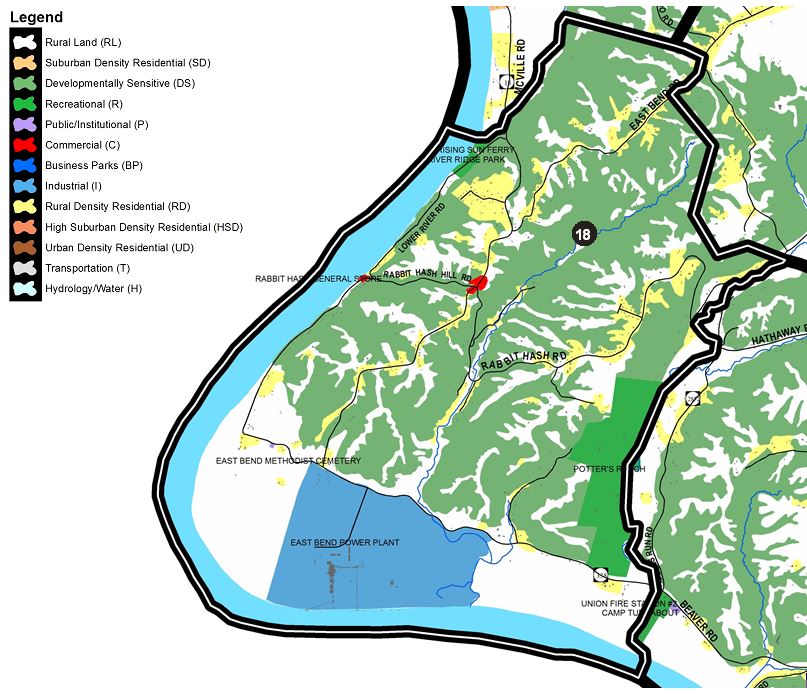
18) RABBIT HASH
This section of Boone County contains Rabbit Hash, the intersection of KY 338/KY 536/KY 18, and considerable Ohio River frontage. It is bound to the west and south by the Ohio River. The northern boundary is defined by Middle Creek to just south of Waterloo Road, while its eastern boundary is up to Gunpowder Creek.
The Rabbit Hash area, including the Rabbit Hash General Store (which was reconstructed in 2016 following a catastrophic fire), has become a significant tourist attraction and should continue as such without compromising its rustic and small town nature. Limited residential growth should occur along the major roads leading to this area. Formal subdivision developments are not recommended, in keeping with the existing character and lack of urban services. The junction of the state routes should provide local service needs that would be inappropriate within the established town of Rabbit Hash. Any commercial uses that may develop at this intersection should have a theme consistent with that of rustic Rabbit Hash. The land along KY 18, which is in crop production, should continue in that capacity. Furthermore, the Developmentally Sensitive hillsides in this region should be protected. In general, growth in this area should be limited. Every attempt should be made to preserve the character of Rabbit Hash in light of its growing popularity and the gaming development across the river. The roads are currently not adequate to handle an increase in traffic to Rabbit Hash or to river access. Overcrowded tourist conditions include such impacts as noise, lack of parking, blockage of the street, trash, etc. should be addressed through strategic improvements defined by the 2004 Rabbit Hash Historical Society Task Force report. In 2018, the “Ms. Lucky Lady” ferry began operating between Rising Sun and a landing at the north end of Lower River Road adjacent to River Ridge Park.
This section of Boone County also contains the East Bend Power Plant and a substantial area of river bottom. The power plant encompasses a large area and much of the developable land. Two large areas to the east and west of the plant are in agricultural use and should remain. The rough terrain to the north of KY 338 is divided by three small creeks. Development of any kind in this area should be limited. Industrial development is inappropriate because of poor access. The backwater area of Lick Creek, east of the power plant, should be examined as a potential wetland wildlife management area. Significant growth is not anticipated for this area because of its remoteness. The potential for tourism exists in this region due to its rich archaeological heritage and historic buildings.
Future growth around Rabbit Hash should be predominantly single-family but should respect the historic character of the area. Typical suburban subdivision development that is occurring in the Florence and Union areas is not possible for this part of the county due to lack of sanitary sewers. Open Space Subdivision Design is one way to accomplish these objectives. The Ohio River views, significant hillsides, and the rustic character of the area should be retained.
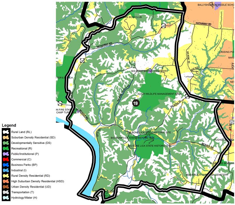
19) BIG BONE
This area is defined to the west by the Ohio River as well as Gunpowder Creek northward through Camp Michaels then eastward to Camp Ernst Road just north of Hathaway Road. The eastern edge is defined by the area just west of Big Bone Road southward just past Teutonia Estates and then to the east just past Big Bone Creek and then southeast towards the intersection of U.S. 42 and Richwood Road. The boundary then heads south along U.S. 42 to just beyond Cleek Lane where it follows Buzzard Branch Creek west to Big Bone Creek and eventually to Big South Fork Creek which defines its southern boundary.
This section of Boone County is characterized by several rural roadways, including KY 338 (Beaver Road), Riddles Run Road, and Big Bone Church Road, as well as a substantial portion of U.S. 42. Even with the rural water line program, residential development will be slow and of a large-lot nature. Large lot subdivisions should provide for connections where appropriate to stream valleys and the future public recreation potential that they provide. It also contains the mouth of Gunpowder Creek. Due to the major creeks and tributaries, much of the land in western portions of this section is Developmentally Sensitive, and should be protected from development. Most of the growth in this area should be of a Rural Density residential nature, located predominately along Beaver Road. Some recreational uses may develop based on the amenities of Gunpowder Creek.
The western half of this section should remain undeveloped or in agricultural uses. Development along Hathaway Road, west of Camp Ernst Road, should be limited. Due to its scenic value, land along the creek and south of Hathaway Road may be suitable for passive recreational uses, as well as promoting tourism in the area. The Boy Scout campground should be protected as recreation land and any adjoining land uses should be designed to be compatible with this facility. Residential development should remain along the existing roads, consolidating access points where appropriate.
The area of KY 338, from Riddles Run Road to Big Bone Church Road, may see the development of some seasonal homes as well as seasonal camping at Big Bone Lick Historic Site and Boone’s Landing. Land between Ryle Road and Boat Dock Road should not be developed due to steep slopes and poor soil conditions. Big Bone Historic Site should continue to expand in size and quality. The property adjacent to Boone’s Landing (known as Jane’s Saddlebag) was rezoned to Recreation for recreation and tourism uses. KY 338, from U.S. 42 to Boat Dock Road, could develop some limited commercial uses, consistent with recreation uses in the area. This possible development is not shown on the Future Land Use Map. Any requests for such uses should be examined carefully in order to ensure that they fit in with the rural and recreational character of the area as well as maintaining safety along KY 338.
This section of Boone County is dominated by several creeks, including Big Bone Creek, Mud Lick Creek, and the Big South Fork Creek along the Boone County/Gallatin County border. Most of the acreage in this section is Developmentally Sensitive, and should remain wooded. Residential development in this area is concentrated on Ryle Road, along the Ohio River. Ryle Road is subject to frequent slippage along the steep river banks. The resulting poor condition of the road limits future residential growth. The existing residential uses along Ryle Road limit potential public access to the river in this area. An effort should be made to connect Big Bone Historic Site with Big Bone Boat Dock. A possible future bridge to Gallatin County would provide an incentive for additional river-related recreation facilities. It could also increase usage of Big Bone Historic Site, making expansion of the park and connection to the riverfront area feasible. Overall, this section should experience very limited residential growth and be oriented towards river access and river recreation activities.
Suburban Residential Development of this section of the county is dependent upon the provision of water and sanitary sewers, and should not negatively impact the Big Bone Creek and Mud Lick Creek watersheds. The water and sanitary sewer services should not commit these two watersheds to extensive development. Even with the rural water line program, residential development will be slow and of a large-lot nature. It is important that residential subdivisions construct internal roadway systems rather than using the existing roads for primary access; these existing roads should serve as corridors to move traffic through the area. Substantial residential growth will compound crowded conditions at the New Haven Elementary School and will require expansion of school facilities.
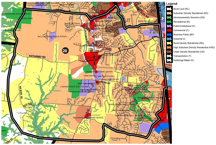
20) UNION
This area is bound to the north by the northern edge of Central Park eastward to Longbranch Road and then north along U.S. 42 to Gunpowder Road where it then heads south to Sunnybrook Drive over to I-75/72 which serves as its eastern boundary south to Heritage Trails and the west edge of commercially zoned property along Frogtown Connector Road and behind the properties that front on Richwood Road. The south boundary is defined by Hicks Pike to Mud Lick Creek where it heads south of Twin Lakes Subdivision and generally westward just beyond Big Bone Road where it heads north forming the west boundary west of Big Bone Road.
This section of Boone County contains the City of Union and a substantial portion of Hathaway Road and U.S. 42. In general, this section should experience considerable residential growth due to Union’s current residential nature, growth associated with the City of Florence, and improvements to U.S. 42. For these reasons, the 2000 Union Town Plan was prepared by the Boone County Planning Commission, City of Union, and Boone County Fiscal Court. The plan’s recommendations are shown on the 2040 Future Land Use Map and also affect the Boone County Zoning Regulations.
The U.S. 42 corridor should experience commercial growth on a smaller scale to mitigate any adverse impacts and to be compatible with surrounding land uses and densities. As defined by the 2000 Union Town Plan, commercial development should occur in neighborhood business district form in specified locations instead of strip style commercial.
Areas west and south of the Union Town Plan area, along U.S. 42, Hathaway Road, and Longbranch Road, contain an existing agricultural, horse farm, and estate residential character. The connections shown in the Union Town Plan need to be continued outside the study area to the next logical properties and arterial roadways. The Frogtown Road corridor has experienced significant residential construction with very little improvement to the existing roadways. Triple Crown sets a good example with its central, limited access boulevard that connects two state-maintained roadways (Frogtown Road and Richwood Road). Significant improvements to roadways will be needed to support extensive growth. Future development in this area should be sensitively designed to minimize impact on existing low density residential land uses, and connecting routes that take traffic off existing roadways should be encouraged.
St. Elizabeth Hospital owns property (93 acres) near the Richwood Road entrance to Triple Crown subdivision that could develop as a health center and should also be sensitive in design to the surrounding residential land uses. In addition, consideration must be given to whether or not Richwood Road can adequately handle the traffic impact of such a use. Improvements to Richwood Road must be completed prior to this property developing into such a use.
New subdivisions should be developed with connecting roads providing alternative routes for residential traffic and decreasing the impact on major roadways. Road connections should include multi-modal elements such as paths, bike lanes, and bus stops to help make Union more pedestrian-oriented. Wetherington Boulevard is an example. Further road connections that prohibit driveway access and street parking should occur between U.S. 42, Camp Ernst Road, Longbranch Road, and Hathaway Road. Hathaway Road needs special attention to protect this important east-west route. Water and sanitary sewer infrastructure should accompany such road connections and extensions as to prevent premature, estate-style residential development, and to prevent frontage subdivisions that result in poor access management. Development proposals shall be carefully evaluated relative to the area-wide road network and any necessary contributions to the network.
Triple Crown Subdivision provides an important road connection between Richwood Road and Frogtown Road. Other connections between Richwood Road and Frogtown Road need to occur. The southwest quadrant of I-75 and Frogtown Road, adjacent to the Frogtown-Richwood Connector Road (KY 3203), should develop as High Suburban Density residential to provide a logical transition of density and a buffer between the major roadways and single family development to the west. However, this area should not include a continuation of the existing mobile home park. Any attached housing in this area must be designed to complement adjacent single-family residential.
Improvements to Mt. Zion Road, between the Union city center and the interchange, should be accompanied by water and sewer improvements to accommodate the anticipated residential growth. The school campus should continue to develop as a community amenity and activity node. Continued residential development in and around Ballyshannon Subdivision should increase the need for expansion of the newly opened Ballyshannon Middle School as well as a possible new elementary school at the site. In addition, connections from the residential developments in the Ballyshannon area to the east are imperative in reducing the reliance upon Longbranch Road and Hathaway Road as the only means of travel towards the Union Town Center proper.
All major residential developments should provide recreational facilities, or other public facilities, through cooperative efforts between developers, legislative bodies, and other agencies/organizations. These facilities should be designed not only to serve the residents of the specific subdivision but, where appropriate, to serve surrounding populations in order to mitigate the impacts upon existing facilities. This section of Boone County should develop as a major population area, and sites for recreation and other public facilities should be planned and obtained before prime sites are no longer available or become too costly for acquisition. The potential to renovate and expand the Union Park property should be considered as a way to accommodate the increasing need for such facilities in the area. The 2006 Parks and Recreation Master Plan called for the property to develop as a family outdoor aquatic center with a multi-purpose building and playground.
The northwest quadrant of the Mt. Zion interchange is the ideal location for urban and higher density residential development. The church use provides a more appropriate transition between the urban density residential and the planned suburban density residential to the west. This would be compatible with the residential character of the area, and should provide housing opportunities for employees of the Florence urbanized area, as well as providing a limit to over-expansion of commercial activity towards Union. The Mt. Zion Road to Weaver Road connector road is needed to provide a parallel route to I-75 as well as enable this growing residential area to access Florence without impacting U.S. 42. It should be located and designed to carry significant traffic volume.

21) RICHWOOD EAST
This area is bound to the west by I-75/71 and to the north by Deer Trace Mobile Home Park east to Dixie Highway and includes the residential properties that front on Maher Road to the Kenton County line which serves as the eastern border. The southern edge is defined by Walton-Nicholson Road and Chambers Road.
There are several major influences behind the anticipated growth in this area, including the Northern Kentucky Industrial Park to the north, the new Mt. Zion interchange, Weaver Road, development pressures along U.S. 25, the extension of public sanitary sewer service, and the Norfolk & Southern Railroad Line. Because of the development pressure, all necessary types of infrastructure should increase in scale. This area is bisected by U.S. 25, a major corridor for growth, extending from urbanized Florence to Walton. The fact that it runs parallel to I-75, and is located between the interstate and the railway, makes it an ideal transportation connector. Because of the various existing and future land uses along U.S. 25, it will carry a high volume of mixed traffic types. For this reason, any traffic-intensive or truck-oriented uses shall locate near connections to the interstate, and access management shall be an important consideration on all development along U.S. 25.
Boone County has established two Tax Increment Financing (TIF) districts in the Richwood Area. Revenues from wage assessments in one district have generated $250,000 to extend water to the site. As additional revenues are collected, the county expects to evaluate other projects, including contributions to the reconstruction of the I-75/Richwood Road Interchange. Great care and consideration must be given to the impacts of increased truck traffic in the area as a result of the development of logistic/warehouse businesses along the U.S. 25 corridor.
Due to its design and its dangerous intersection with U.S. 25, Maher Road should remain an enclave of residential uses, and no industrial access should be provided along this road. Industrial uses abutting this residential area must be planned with adequate buffering for the existing and future residential development. The industrial area to the south of Maher Road should be accessed via Frogtown Road, and the possibility of extending East Frogtown Road to connect with Maher Road should be explored because of the better visibility at the railroad crossing and intersection with U.S. 25. The frontage along U.S. 25 is suitable for a mixture of commercial and light industrial activity with proper access management provisions.
Industrial growth can occur around the northbound I-75 rest stop, but should provide a buffer to hide outside storage and pavement areas from the rest stop and interstate. The U.S. 25 and Frogtown Road intersection should support locally-oriented commercial uses. However, special attention should be given to controlling and coordinating access points with this area. Multiple street connections are critical in the area south of the Mt. Zion interchange and west of I-75 to avoid burdening specific connections with too much traffic.
The Infrastructure For Rebuilding America (INFRA) Grant reconstruction of the Richwood interchange in 2019 and associated improvements to Richwood Road will substantially increase capacity. Commercial development around the interchange area is expected to remain and expand to serve local residents in addition to highway-related services. Intrusive highway related services should not impact the low density residential uses on the west, and be limited to the east side of I-75. The industrial development should primarily occur on the east side of U.S. 25, and south of the existing commercial area, as well as along Old Lexington Pike. Any intensive industrial uses proposed for Boone County should be directed to this area because of the distance from residential uses and the proximity to rail services. As a result of the reconstruction of the interchange area, rail spur expansion could lead to better access to rail services in the area. Old Lexington Pike should be upgraded as needed to serve as an access road for these industrial uses. In summary, the planned improvements to the Richwood interchange and the construction of a Single Point Urban Interchange (SPUI) with an underpass of the existing Norfolk & Southern rail line at the U.S. 25 and KY 338 intersection are imperative to development of over 1,000 acres in Boone and Kenton counties south and east of U.S. 25 and Richwood Road and east of Old Lexington Pike. Industrial uses fronting on U.S. 25 should be developed with attention given to adequate aesthetic design and landscaping to minimize visual impacts to the residential uses across I-75. Highway commercial growth should not occur to the point of blocking industrial traffic from future planned industrial development along U.S. Highway 25. Commercial development in this area should be designed to serve nearby residential growth occurring southwest of the interchange along Richwood Road.
The area between U.S. 25 and the Boone/Kenton County line contains industrial potential due to interstate and rail access. Development of this area should utilize Old Lexington Pike as a frontage road to limit the number of access points onto Dixie Highway. Business development to the east of Walton should be facilitated by major roadway improvements extending east from Mary Grubbs Highway and ultimately connecting with major thoroughfares in Kenton County – including KY 16 and KY 17.
Commercial uses should develop in the northeast quadrant of the Richwood interchange, but further truck-oriented commercial uses in this area should be discouraged because of the existing traffic congestion and topographical constraints of the interchange. The commercial areas need to be adequately buffered from the existing residential areas, and should not include uses which require outside display of products. The area to the north of the interstate commercial area and south of the existing mobile home park should develop as commercial uses that are consistent in design and serve the single family residential developments in this area. Care must be taken to mitigate any of the adverse impacts of commercial development, due to the proximity of the interstate and residential uses.
The area east of I-75 and west of U.S. 25, from Richwood Road to Chambers Road, should develop as a Business Park. A buffer should be provided along Chambers Road to residential uses to the south, and no business park access should occur on Chambers Road. New industrial or business park developments south of the improvements being made to U.S. 25/Dixie Highway as part of the I-75/Richwood Road Interchange rebuild requiring new access to Dixie Highway must be accompanied by a Traffic Impact Study to determine if the existing conditions of the road are able to support additional truck traffic. If new improvements are warranted, a combined effort of State, County, and private funds shall be explored to share in the cost of the improvements. All developments should be interconnected by roadways to provide a parallel system to U.S. 25.
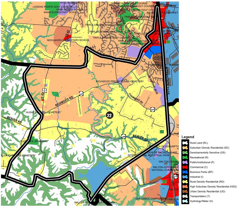
22) RICHWOOD WEST
This area is bound to the east by I-75/71 and then I-71 south to McCoy’s Fork Creek just south of the Bavarian landfill. The south boundary is set by McCoy’s Fork Creek and Mud Lick Creek to U.S. 42 just south of Moore Road and then the west boundary is defined by U.S. 42 up to its intersection with Richwood Road where it then moves west behind properties fronting on U.S. 42 until just south of Twin Lakes Subdivision where it then heads east to a branch of the Mud Lick Creek before heading north to Hicks Pike and then northeast behind properties fronting on Richwood Road.
Development to the southwest of the Richwood interchange must continue the Grand National Boulevard connection to Chambers Road. The remaining portion of the Grand National Boulevard to Chambers connection should be completed when the new elementary school is developed if warranted. The reconstruction of the I-75/Richwood Road interchange is expected to occur in 2019 which may lead to the need for additional retail and office uses. The remaining undeveloped land on the southwest quadrant of I-75 and Richwood Road is recommended for Business Park and Urban Residential. The Business Park area along Richwood Road should develop as an attractive office campus project that provides an appropriate entrance to the residential corridor between Steeplechase and Chambers Road. Any business development along Grand National Boulevard must include proper ingress and egress, and provide for needed modifications to the roadway and/or its intersection with KY 338. Highway related commercial growth on the west side of the interchange should be adequately buffered from existing and planned residential uses. As the residential area of Richwood grows, especially with the development of the Triple Crown community, neighborhood and convenience commercial uses should develop. These new uses should be oriented toward the residents rather than the highway traveler. Commercial development along Richwood Road should be screened from the roadway, and serve the developing residential uses in the Richwood – Union area. Curb cuts should be limited and consolidated wherever possible. Beaverlick should remain as a small community with little growth. Any commercial development in this area should locate at the intersection of U.S. 42 and Beaver Road in Beaverlick.
Improvements to roadways in this area will be needed to support extensive growth. Future development in this area should be sensitively designed to minimize impact on existing low density residential land uses. Connecting routes that take traffic off existing roadways should be encouraged. Significant cultural resources are also located in this area, including Richwood Presbyterian Church, a National Register listed prehistoric village site (protected by conservation easement) and hundreds of acres of the historic Gaines Farm, known for its association with Margaret Garner, who escaped captivity there with her husband and children in 1856.
This section also contains the Bavarian landfill site. The landfill should not expand to the south because of the McCoys Fork Creek and should not expand to the north in order to avoid additional impacts on existing residential uses. The operation and area of the landfill should be evaluated by the Boone County Planning Commission and other appropriate agencies in order to determine environmental and land use impacts associated with this use. Future land uses on the surface of the landfill area may include some forms of recreation activity. However, the development should not include industrial activity since the access to the area is through a residential corridor.
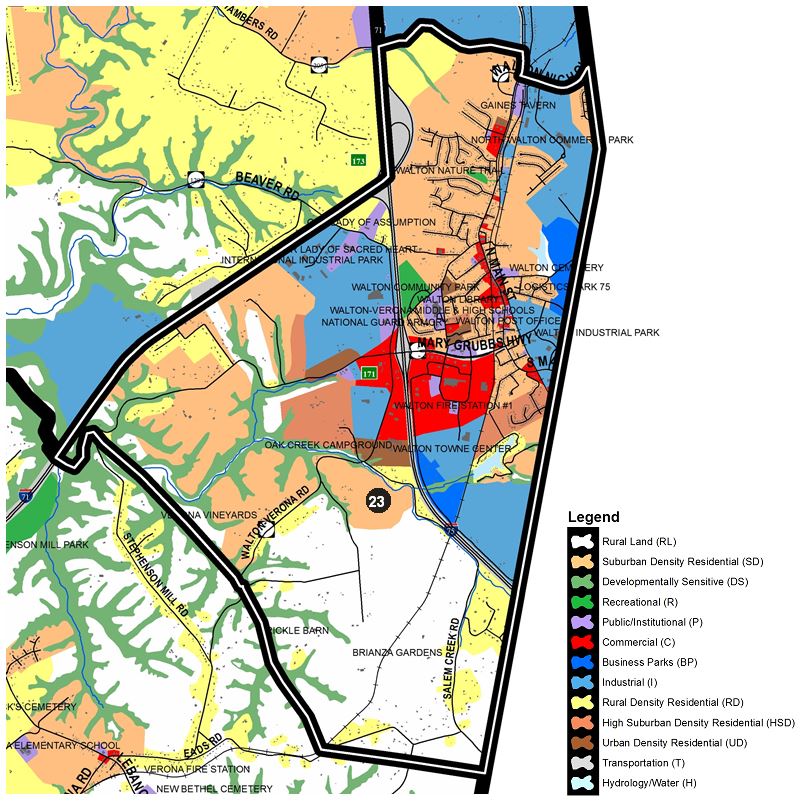
23) WALTON
This area is bound to the east by the Kenton County line. The south boundary is just south of Eads Road where it then follows Little Salem Creek valley northwest to I-71 and northward to I-75/71 to the northern boundary set by Chambers Road and Walton-Nicholson Road.
The Walton area should continue to experience gradual commercial, residential, and industrial growth. This growth should result primarily from the Walton interchange and its location near the intersection of I-71 and I-75. Walton lies along this regional interstate corridor, between Cincinnati to the north and Louisville, Lexington, and Frankfort to the south that is generally experiencing demand for industrial development. The City of Walton is being surrounded by industrial development and zoning to the north, south, and west of the City. The extension of Mary Grubbs Highway has contributed to the growth of Walton not only in Boone County, but also into Kenton County to the east as it serves the large industrial properties just across the county line. Regarding the Walton Towne Center, the potential for a mix of uses including high density residential, commercial, office, institutional, and recreational should occur. Light industrial is most appropriate in the south portion of the property and along the CSX rail line.
The 2018 Boone County Transportation Plan calls for an Interchange Justification Study to identify long-term safety and congestion improvements at the I-75/Mary Grubbs Highway interchange as well as another study to identify short-term safety and congestion improvements for the southbound exit ramp and intersection with KY 14.
In the area of the former Walton Reservoir, between the county line and the railroad tracks, mixed use development with office campus and residential neighborhoods should complement a future road network. This road network is necessary for proper development of the area and should include a future major route toward KY 17 in Kenton County and a route to KY 16 in Boone County near the county line. Existing industrial developments in this area should continue to develop. However, some residential development is appropriate in the area if it has adequate access that is not industrial in character. Residential access through industrial areas should be accompanied by significant streetscape improvements. Residential developments need to be connected and be served by several ways in and out of this area. This would allow the central portion of Walton to experience residential growth in response to the employment growth and utility expansion in the area.
Suburban Residential development is occurring south of Chambers Road, between I-75 and U.S. 25. The rougher terrain, immediately adjacent to Chambers Road should include lower density residential development that minimizes traffic on this roadway, and fits into the landscape along this highly visible portion of the interstate corridor. The suitability of this area for residential use is enhanced by proximity to developing recreation areas, commercial services, and the Walton-Verona schools. Commercial development along U.S. 25 should also experience infilling, and should remain local in nature. The Walton Main Street Strategic Plan was conducted in 2015 to assess and protect its historic resources and small town character. Walton’s Main Street is the most functional business district with a small town character in the county. The Gaines Tavern, listed on the National Register, is north of town and South Main Street from south of the post office to the end of Old South Main Street is a National Register Historic District. The recommendations in the Strategic Plan should be considered and followed in order to preserve the historic character of Walton’s downtown in light of new development occurring in the Walton Towne Center. In addition to historic resources, the Walton and Verona areas are home to heritage tourism resources including four vineyards (Verona Vineyards, Brianza Gardens & Winery, Schoolyard Winery, Barker’s Blackberry Hill Winery) and the rustic Prickel Barn event center.
Mary Grubbs Highway and U.S. 25 to the Boone County line is a critical development area because of the recently completed extension of Mary Grubbs Highway to the east. The traffic and operational capacity of both Mary Grubbs Highway and U.S. 25 should be evaluated for possible improvements in the future as the Town Center project is built out and potential industrial development is created to the north and south of this area. Both of these roads are critical to the economic viability of the City of Walton. Some commercial uses may be appropriate at the front of this area if designed to serve growing residential uses in the area. Most development at this future high visibility location should be of a Business Park nature. Commercial development should also occur at the southeast quadrant of the interchange, and be designed carefully to provide a front door to the City of Walton. Business Park development should occur behind the commercial uses. Development at this location should not be oriented to truck-traffic. Attention should be given to the appearance of industrial uses from the interstate in this area, because it represents the southern entrance into Boone County. Residential uses to the south of the city and east of the interstate should not exceed the Rural Density classification unless adequate sanitary sewer and water services are extended. Intensive industrial development in the south Walton area should occur south of Boone Lake and west of U.S. 25 towards I-75.
The area south of I-71 and west of I-75 to Stephenson Mill Road is suitable for light industrial development. Access to this industrial area should connect to Beaver Road and Stephenson Mill Road. Urban Density Residential is appropriate to act as a transition between the Suburban Residential and Industrial uses along Stephenson Mill Road. However, before these areas develop, improvements to Stephenson Mill Road and Beaver Road will be necessary. In addition, improvements to the intersection of these two roads and the interstate will be necessary. Suburban Residential will be appropriate to the west along Stephenson Mill Road if utilities are extended into this area. Commercial development of the northwest quadrant of the Mary Grubbs interchange should be of a type to serve the adjoining industrial area, while the southwest quadrant of the interchange will continue to be dominated by the Flying J development. However, traffic circulation improvements are needed at this specific location. There should be no further development of commercial uses oriented to truck traffic. The remaining area in this section should be Rural Density Residential or agricultural in nature.
24) VERONA
This section is bound to the east by the Kenton County line and the south by the Grant County and Gallatin County lines. The west edge is set by Big Bone Creek and then heads inland to form the north boundary as it follows Mud Lick Creek and then Buzzard Branch before heading east to Mud Lick Creek and then McCoy’s Fork Creek. Once across I-71, the northern boundary follows the Little Salem Creek southeast to Eads Road where it then heads due east to the Kenton County line.
This area is characterized by the town of Verona, the I-71/KY 14 interchange, and the Boone County portion of Bullock Pen. The Walton-Verona School District has athletic fields in the front section of Waller-Stephenson Park on the south side of the I-75/KY 14 interchange. Future plans call for construction of a high school on the site. Local and interstate-related commercial development is appropriate around this interchange. This commercial district should primarily serve the Verona area. Adjacent to this development, south of the interchange, High Suburban Density Residential development can occur, although the area lacks public sanitary sewer. This would provide a higher density residential opportunity in this non-urbanized portion of the county. Access to this residential development should be by a road connection to KY 14 at an adequate distance from the interchange to avoid future traffic congestion. Additional residential development in this section of the county should be Rural Density in nature and should occur along the established roadways. Development along KY 14 should reinforce the rural estate character of Verona Commons Subdivision.
Residential development in the Verona area is encouraged by the availability of public water. The town of Verona should experience limited residential and commercial growth. Neo-traditional and Suburban Density development should be encouraged immediately surrounding the town. Commercial development between downtown Verona and the interchange should be discouraged in order to preserve the small community nature of the town. A detailed study is needed for this area, particularly near the interchange, in order to coordinate the residential and commercial development as well as the infrastructure. At the same time, this study could examine the idea of utilizing performance standards as a means of achieving quality development design. Currently, the zoning in this area does not correspond with the Future Land Use Map. This should be evaluated during the county-wide zoning update or through a special study.
Any further residential development in the vicinity of Bullock Pen Lake should be of a Rural Density nature and should occur along existing roads. In general, little growth should occur in this part of the Verona section. The growth of this part of the county is tied to Verona and Walton and any development should be related to these towns. Further residential development around the lake should be discouraged, due to the lack of infrastructure and the importance of preserving Bullock Pen Lake as a water and recreation resource. Generally, this area should remain in Rural Density Residential and focus on agricultural uses. In the South Fork area, growth should be minimal along U.S. 42 near the border with Gallatin County in the form of Rural Density residential uses.